Military Maps of Scotland (18th century)
| Field | Content |
|---|---|
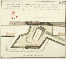
| Title: | Plan, Elevation and Section of the South Bastion of Fort William, Shewing the Breach occasion'd by the Shooting of Part of the Scarp Wall [copy] |
| Name: | Walker, Thomas (Engineer) Gould, Francis (Draughtsman) |
| Description: | 1 manuscript map ; 267 x 303 mm., on sheet, 291 x 337 mm. |
| Original Survey: | [1751] |
| Date on Map: | 1781 |
| Placename: | Fort William, |
| Parish: | Kilmallie |
| County: | Inverness-shire |
| Shelfmark: | MS.1646 Z.02/31b |
| Zoom Into Map: | Click on the map to view in greater detail. |