Military Maps of Scotland (18th century)
| Field | Content |
|---|---|
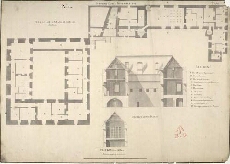
| Title: | Sterling Castle, November 1719. No.1: Plan of the 3d Stage at A in the Section |
| Name: | Jelfe, Andrews (Architect) Moore, Thomas (Engineer) |
| Description: | 1 manuscript map ; 520 x 735 mm., on sheet, 544 x 756 mm. |
| Original Survey: | 1719 |
| Date on Map: | 1719 |
| Placename: | Stirling |
| Parish: | Stirling |
| County: | Stirlingshire |
| Shelfmark: | MS.1646 Z.02/18a |
| Zoom Into Map: | Click on the map to view in greater detail. |