Map details:
| Field | Content |
|---|
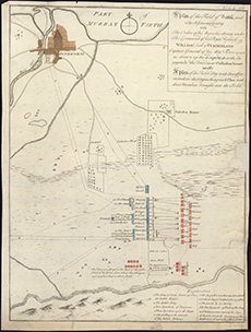
| Title: | A plan of the field of battle, and the adjacent country with the order of His Majesties Army ... as drawn up the 16 April 1746 at the engag[men]t w[ith] the rebels near Cullodon House as also a plan of the rebel army ... distinguishing each clan with thei |
| Description: | 1 map ; 437 x 330 mm. |
| Original Survey: | 1746 |
| Date on Map: | 1746 |
| Placename: | Culloden |
| Parish: | Inverness, Croy, Daviot and Dunlichity |
| County: | Inverness-shire |
| Shelfmark: | EMS.s.158 |
| Zoom Into Map: | Click on the map to view in greater detail. |