Military Maps of Scotland (18th century)
| Field | Content |
|---|---|
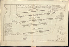
| Title: | A plan of ye disposition of both army's, in yt. ever memorable battle & defeat of ye rebels by his R.H. ye Duke of Cumberland. Ap. 16, 1746 near Collodon House. |
| Description: | 1 map ; 238 x 397 mm |
| Original Survey: | 1746 |
| Date on Map: | 1746 |
| Placename: | Culloden |
| Parish: | Inverness, Croy, Daviot and Dunlichity |
| County: | Inverness-shire |
| Shelfmark: | EMS.s.157A |
| Zoom Into Map: | Click on the map to view in greater detail. |