Military Maps of Scotland (18th century)
| Field | Content |
|---|---|
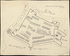
| Title: | Description of the forts of Inverloughee. |
| Description: | 1 map ; 382 x 482 mm |
| Original Survey: | 1656 |
| Date on Map: | 1656 |
| Placename: | Fort William |
| Parish: | Kilmallie |
| County: | Inverness-shire |
| Shelfmark: | EMS.s.89 |
| Zoom Into Map: | Click on the map to view in greater detail. |
All images © National Library of Scotland