Military Maps of Scotland (18th century)
| Field | Content |
|---|---|
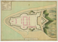
| Title: | A plan of Fort George North Britain Design[e]d & exec[ute]d by Skinner, Chief Engineer |
| Description: | 1 manuscript map : hand col. ; 52 x 74 cm. |
| Original Survey: | 1763 |
| Date on Map: | 1763 |
| Placename: | Fort George (Ardersier) |
| Parish: | Ardersier |
| County: | Inverness-shire |
| Shelfmark: | EMS.s.801 |
| Zoom Into Map: | Click on the map to view in greater detail. |
All images © National Library of Scotland