Military Maps of Scotland (18th century)
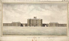
| Field | Content |
|---|---|
| Title: | North Elevation of Gordon Castle |
| Name: | Carte (Clark?), Thomas [Storekeeper] |
| Description: | 1 manuscript map ; 246 x 496 mm., on sheet, 320 x 535 mm. |
| Placename: | Gordon Castle |
| Parish: | Bellie |
| County: | Elginshire/Moray |
| Shelfmark: | MS.1650 Z.46/63 |
| Zoom Into Map: | Click on the map to view in greater detail. |
All images © Crown Copyright and © National Library of Scotland