Military Maps of Scotland (18th century)
| Field | Content |
|---|---|
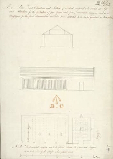
| Title: | Plan Front Elevation and Section of a shade proposed to be erected at Ayr and Aberdeen for the protection of four guns and four Ammunition waggons, and as a Magazine for the fixed Ammunition and other stores, attached to the troops quartered at those plac |
| Description: | 1 manuscript map ; 466 x 331 mm. |
| Placename: | Aberdeen (Cumberland Fort?), Ayr |
| County: | Aberdeenshire, Ayrshire |
| Shelfmark: | MS.1650 Z.46/62 |
| Zoom Into Map: | Click on the map to view in greater detail. |