Military Maps of Scotland (18th century)
| Field | Content |
|---|---|
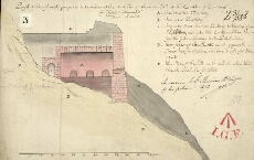
| Title: | Profil of the flanck proposed to be made at the West End of the new Wall at the Castle of Edinburgh |
| Name: | Edwards, Talbot (Engineer) |
| Description: | 1 manuscript map ; 242 x 372 mm. |
| Original Survey: | 1710 |
| Date on Map: | 1710 |
| Placename: | Edinburgh Castle |
| Parish: | Edinburgh |
| County: | Edinburghshire/Midlothian |
| Shelfmark: | MS.1649 Z.03/58d |
| Zoom Into Map: | Click on the map to view in greater detail. |