Military Maps of Scotland (18th century)
| Field | Content |
|---|---|
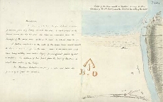
| Title: | Sketch of the River mouth at Montrose shewing the Bar Situation of the old Battery and the Point on the south of the River [with report] |
| Name: | Gravat, William (Engineer) |
| Description: | 1 manuscript map ; 232 x 367 mm. |
| Original Survey: | 1795 |
| Date on Map: | 1795 |
| Placename: | Montrose |
| Parish: | Montrose |
| County: | Forfarshire/Angus |
| Shelfmark: | MS.1649 Z.03/56c |
| Zoom Into Map: | Click on the map to view in greater detail. |
All images © Crown Copyright and © National Library of Scotland