Military Maps of Scotland (18th century)
| Field | Content |
|---|---|
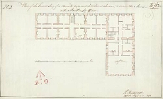
| Title: | Plan of the Ground Story of a Barrack, proposed to be erected at Aberdeen, to Contain 360 Men, with a Pavillion for Officers No. 3 |
| Name: | Rudyard, Henry (Engineer) |
| Description: | 1 manuscript map ; 272 x 453 mm., on sheet, 288 x 468 mm. |
| Original Survey: | 1792 |
| Date on Map: | 1792 |
| Placename: | Cumberland Fort, Aberdeen |
| Parish: | Old Machar |
| County: | Aberdeenshire |
| Shelfmark: | MS.1649 Z.03/52a |
| Zoom Into Map: | Click on the map to view in greater detail. |
All images © Crown Copyright and © National Library of Scotland