Military Maps of Scotland (18th century)
| Field | Content |
|---|---|
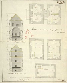
| Title: | Plan of the Repairs for Corgarff Castle |
| Name: | Watson, David (Engineer) |
| Description: | 1 manuscript map ; 353 x 277 mm., on sheet, 369 x 304 mm. |
| Original Survey: | 1748 |
| Date on Map: | 1748 |
| Placename: | Corgarff Castle |
| Parish: | Strathdon |
| County: | Aberdeenshire |
| Shelfmark: | MS.1649 Z.03/37c |
| Zoom Into Map: | Click on the map to view in greater detail. |