Military Maps of Scotland (18th century)
| Field | Content |
|---|---|
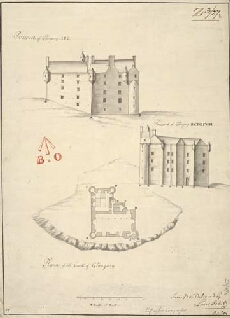
| Title: | Plann of the Castle of Glangary; Prospect of Glangary ABC; Prospect of Glangary BCDEFGH |
| Name: | Petit, Lewis (Engineer) |
| Description: | 1 manuscript map ; 468 x 341 mm., on sheet, 513 x 357 mm. |
| Original Survey: | [1714] |
| Date on Map: | [1714] |
| Placename: | Glengarry |
| Parish: | Kilmonivaig |
| County: | Inverness-shire |
| Shelfmark: | MS.1648 Z.03/27a |
| Zoom Into Map: | Click on the map to view in greater detail. |