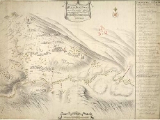
Map details:
| Field | Content |
|---|
| Title: | A Plan of the Field of Battle that was fought on the 10th of Iune 1719, at the Pass of Glenshiels in Kintail North Britain with ye Disposition of his Majtys Forces under ye Command of Majr. Genl. Wightman, & of those of ye Rebels [copy] |
| Name: | Bastide, John Henri (Engineer) |
| Description: | 1 manuscript map ; 494 x 563 mm., on sheet, 502 x 673 mm. |
| Original Survey: | [1719?] |
| Date on Map: | [1719?] |
| Placename: | Glenshiel |
| Parish: | Glenshiel |
| County: | Ross & Cromartyshire |
| Shelfmark: | MS.1648 Z.03/22b |
| Zoom Into Map: | Click on the map to view in greater detail. |