Military Maps of Scotland (18th century)
| Field | Content |
|---|---|
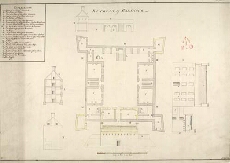
| Title: | Ruthvan of Badenock |
| Name: | Jelfe, Andrews (Architect) |
| Description: | 1 manuscript map ; 480 x 704 mm., on sheet, 531 x 731 mm. |
| Original Survey: | ca.1719 |
| Date on Map: | ca.1719 |
| Placename: | Ruthven |
| Parish: | Kingussie |
| County: | Inverness-shire |
| Shelfmark: | MS.1648 Z.03/20a |
| Zoom Into Map: | Click on the map to view in greater detail. |
All images © Crown Copyright and © National Library of Scotland