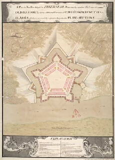
Map details:
| Field | Content |
|---|
| Title: | A Plan of a New Fort design'd for Inverness, Done exactly upon the Old Lines of Olivers Fort; with the additional Outworks of Cover'd-way, Lunettes and Glassis; all which are more fully explain'd in the particular Plans & Sections |
| Name: | Marcell, Lewis (Engineer) |
| Description: | 1 manuscript map ; 503 x 488 mm., on sheet, 729 x 527 mm. |
| Original Survey: | 1746 |
| Date on Map: | 1746 |
| Placename: | Fort George (Inverness) |
| Parish: | Inverness and Bona |
| County: | Inverness-shire |
| Shelfmark: | MS.1647 Z.02/83a |
| Zoom Into Map: | Click on the map to view in greater detail. |