Military Maps of Scotland (18th century)
| Field | Content |
|---|---|
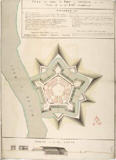
| Title: | Plan for building a Fort at Inverness on the Vestige of an old Fort demolished 1746 [copy] |
| Name: | Skinner, William (Engineer) Tarrant, Charles (Draughtsman) Thomas Smart (Copyist) |
| Description: | 1 manuscript map ; 731 x 512 mm., on sheet, 743 x 522 mm. |
| Original Survey: | 1746 |
| Date on Map: | 10 August 1764 |
| Placename: | Fort George (Inverness) |
| Parish: | Inverness and Bona |
| County: | Inverness-shire |
| Shelfmark: | MS.1647 Z.02/82a |
| Zoom Into Map: | Click on the map to view in greater detail. |