Military Maps of Scotland (18th century)
| Field | Content |
|---|---|
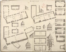
| Title: | Dunbarton Anno 1719 |
| Name: | Jelfe, Andrews (Architect) Moore, Thomas (Engineer) |
| Description: | 1 manuscript map ; 465 x 584 mm., on sheet, 487 x 606 mm. |
| Original Survey: | 1719 |
| Date on Map: | 1719 |
| Placename: | Dumbarton Castle |
| Parish: | Dumbarton |
| County: | Dumbartonshire |
| Shelfmark: | MS.1647 Z.02/73 |
| Zoom Into Map: | Click on the map to view in greater detail. |