Map details:
| Field | Content |
|---|
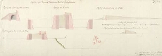
| Title: | Profils of the Proposed Additional Works at Fort Augustus; Profil of the Fort through the Courtine; Profil of the Ravelin; Profil of the Covered way and Glassis; Profil through the line A.B in the Plan; Profil of the Entrenchment before the Entrance of th |
| Name: | Marcell, Lewis (Engineer) |
| Description: | 1 manuscript map ; 469 x 758 mm. |
| Original Survey: | 1746 |
| Date on Map: | 1746 |
| Placename: | Fort Augustus |
| Parish: | Boleskine and Abertarff |
| County: | Inverness-shire |
| Shelfmark: | MS.1647 Z.02/64b |
| Zoom Into Map: | Click on the map to view in greater detail. |