Military Maps of Scotland (18th century)
| Field | Content |
|---|---|
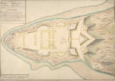
| Title: | Plan of Fort George North Britain Shewing how far the Works are Carried on in 1750 and what is propos'd to be done in 1751 [copy] |
| Name: | Skinner, William (Engineer) Tarrant, Charles (Draughtsman) Day, Thomas (Copyist) |
| Description: | 1 manuscript map ; 516 x 736 mm., on sheet, 553 x 767 mm. |
| Original Survey: | 1750 |
| Date on Map: | 1750 |
| Placename: | Fort George (Ardersier) |
| Parish: | Ardersier |
| County: | Inverness-shire |
| Shelfmark: | MS.1646 Z.02/40b |
| Zoom Into Map: | Click on the map to view in greater detail. |