Military Maps of Scotland (18th century)
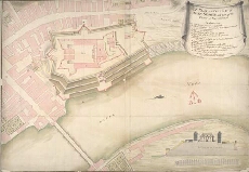
| Title: | A Plan and Section of Fort George with part of the Town of Inverness [about 1730] |
| Description: | 1 manuscript map ; 512 x 741 mm., on sheet, 539 x 755 mm. |
| Original Survey: | [ca.1730] |
| Date on Map: | [ca.1730?] |
| Placename: | Fort George (Inverness) |
| Parish: | Inverness and Bona |
| County: | Inverness-shire |
| Shelfmark: | MS.1646 Z.02/38 |
| Zoom Into Map: | Click on the map to view in greater detail. |
All images © Crown Copyright and © National Library of Scotland