Military Maps of Scotland (18th century)
Your search returned 5 records.
Ordered chronologically (undated items first).
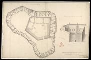
| Title: | Plann of Castle Tyrholme; Profile of Castle Tyrholme upon the Line CAB | |
| Name: | Petit, Lewis (Engineer) | |
| Survey: | [1714] | |
| Shelfmark: | MS.1648 Z.03/25a | |
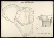
| Title: | Plan of Castle Tyrholme; View of Castle Tyrholme on the Sides C,A,B [copy] 1741 | |
| Name: | Petit, Lewis (Engineer) | |
| Survey: | 1741 | |
| Shelfmark: | MS.1648 Z.03/25b | |
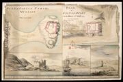
| Title: | Plan of Castle Tyrim in Muydart; Plan of Castle Duirt in the Island of Mull 1748 [copy] | |
| Name: | Watson, David (Engineer) Sandby, Paul (Draughtsman) | |
| Survey: | 1748 | |
| Shelfmark: | MS.1648 Z.03/28d | |
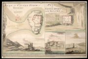
| Title: | Plan of Castle Tyrim in Muydart; Plan of Castle Duirt in the Island of Mull 1748 | |
| Name: | Watson, David (Engineer) Sandby, Paul (Draughtsman) | |
| Survey: | 1748 | |
| Shelfmark: | MS.1648 Z.03/28e | |
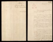
| Title: | Report of Castle Tyrrim, Castle Duirt and the Castle in Island Stalker | |
| Name: | Watson, David (Engineer) | |
| Survey: | 1748 | |
| Shelfmark: | MS.1648 Z.03/28f | |