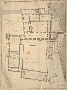
Military Maps of Scotland (18th century)
| Field | Content |
|---|---|
| Name: | [Dury, Theodore] |
| Title: | Ground Floor of the Palace at Stirling Castle |
| Original Survey: | [1708] |
| Date on Map: | [1708] |
| Description: | 1 manuscript map ; 455 x 334 mm., on sheet, 485 x 364 mm |
| Placename: | Stirling |
| County: | Stirlingshire |
| Shelfmark: | MS.1646 Z.02/17 |
| Zoom Into Map: | Click on the maps below to order image or view in greater detail. |
 |
 |