Military Maps of Scotland (18th century)
Map details:
| Field | Content |
|---|
| Name: | Skinner, William
Tarrant, Charles |
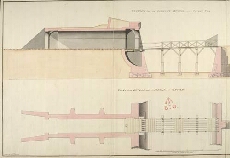
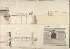
| Title: | [Fort George, North Britain] 1752, No. 4; Section thro' the Gateway, Bridge, and Coverd-Way; Plan of the Bridge and Gateway to the Ravelin; Elevation of the Front of the Gateway |
| Original Survey: | 1752 |
| Date on Map: | 1752 |
| Description: | 1 manuscript map ; 491 x 671 mm., on sheet, 520 x 1084 mm |
| Placename: | Fort George (Ardersier) |
| Parish: | Ardersier |
| County: | Inverness-shire |
| Shelfmark: | MS.1646 Z.02/46b |
| Zoom Into Map: | Click on the maps below to order image or view in greater detail. |
Copyright Enquiries & Copies Help