Military Maps of Scotland (18th century)
| Name: | Romer, John Lambertus |
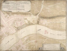
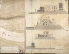
| Title: | A Plan of Fort George, & part of the Town of Inverness, with proper Sections relating to the Fort. Anno 1732 |
| Original Survey: | 1732 |
| Date on Map: | 1732 |
| Description: | 1 manuscript map ; 515 x 1096 mm., on sheet, 531 x 1111 mm |
| Placename: | Fort George (Inverness) |
| Parish: | Inverness and Bona |
| County: | Inverness-shire |
| Shelfmark: | MS.1646 Z.02/34a |
| Zoom Into Map: | Click on the maps below to order image or view in greater detail. |
All images © Crown Copyright and © National Library of Scotland
Copyright Enquiries & Copies Help