Mapmakers
Your search for Winter, Thomas returned 3 records.
Ordered chronologically (undated items first).
| Field | Content | |
|---|---|---|
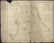
| Name: | Winter, Thomas (fl. 1742) | |
| Title: | A chart of the Solway Firth... according to an exact survey made anno 1742 | |
| Imprint: | Published by the Town of Dumfries, 1744 | |
| Zoom Into Map: | Click on the map to view in greater detail. | |
| Field | Content | |
|---|---|---|
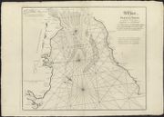
| Name: | Winter, Thomas (fl. 1742) | |
| Title: | A chart of Solway Firth describing the banks & coasts of England and Scotland from St. Beeshead and the Ross of Kirkcudbright to the harbour of Carse in the river of Nith according to an exact survey made anno 1742 / Thomas Winter ; R. Cooper sculp. | |
| Imprint: | Dumfries : Town of Dumfries 1744. | |
| Zoom Into Map: | Click on the map to view in greater detail. | |
| Field | Content | |
|---|---|---|
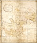
| Name: | Winter, Thomas (ca. 1726-63) | |
| Title: | A plan of the estates of Kethick and Benochie consisting of the lands of Kethicks Caddam and Kempshill; Coutie, Coutiehill and Benochie, with the Boat Lands and Foulfoord : the property of James Mackenzie of Rosehaugh | |
| Imprint: | Surveyed: 1751 | |
| Zoom Into Map: | Click on the map to view in greater detail. | |