Mapmakers
Your search for Tait, John returned 25 records.
Ordered chronologically (undated items first).
| Field | Content | |
|---|---|---|
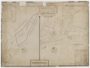
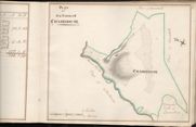
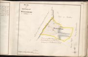
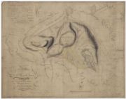
| Name: | Tait, John (fl. ca 1752-1782) | |
| Title: | Plan of Broom-House & Croft Head | |
| Imprint: | 1753 | |
| Zoom Into Map: | Click on the map to view in greater detail. | |
| Field | Content | |
|---|---|---|
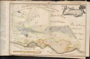
| Name: | Tait, John (fl. ca 1752-1782) | |
| Title: | Plan of the farms of Shambelly, Townhead, Wanfoord, Clachrumheads and Barsay, belonging to Charles Stewart, Esqr | |
| Imprint: | 1759(?) | |
| Zoom Into Map: | Click on the map to view in greater detail. | |
| Field | Content | |
|---|---|---|
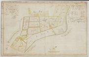
| Name: | Tait, John (fl. ca 1739-1797) | |
| Title: | Farm of Glen belonging to Charles Stewart of Shambelly Esq | |
| Imprint: | 1759 | |
| Zoom Into Map: | Click on the map to view in greater detail. | |
| Field | Content | |
|---|---|---|
| Name: | Tait, John, ca. 1752-1782 (surveyor) Udny, Joseph, fl. ca 1770-1828 (draughtsman) | |
| Title: | Plan of the Farm of Cowburn | |
| Imprint: | 1760 | |
| Zoom Into Map: | Click on the map to view in greater detail. | |
| Field | Content | |
|---|---|---|
| Name: | Tait, John, ca. 1752-1782 (surveyor) Udny, Joseph, fl. ca 1770-1828 (draughtsman) | |
| Title: | Plan of the Farm of Craighouse | |
| Imprint: | 1760 | |
| Zoom Into Map: | Click on the map to view in greater detail. | |
| Field | Content | |
|---|---|---|
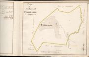
| Name: | Tait, John, ca. 1752-1782 (surveyor) Udny, Joseph, fl. ca 1770-1828 (draughtsman) | |
| Title: | Plan of the Farm of Corrie-hill | |
| Imprint: | 1760 | |
| Zoom Into Map: | Click on the map to view in greater detail. | |
| Field | Content | |
|---|---|---|
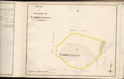
| Name: | Tait, John, ca. 1752-1782 (surveyor) Udny, Joseph, fl. ca 1770-1828 (draughtsman) | |
| Title: | Plan of the Farm of Corrie-halls | |
| Imprint: | 1760 | |
| Zoom Into Map: | Click on the map to view in greater detail. | |
| Field | Content | |
|---|---|---|
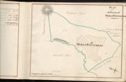
| Name: | Tait, John, ca. 1752-1782 (surveyor) Udny, Joseph, fl. ca 1770-1828 (draughtsman) | |
| Title: | Plan of Meikle Whiteriggs | |
| Imprint: | 1760 | |
| Zoom Into Map: | Click on the map to view in greater detail. | |
| Field | Content | |
|---|---|---|
| Name: | Tait, John, ca. 1752-1782 (surveyor) Udny, Joseph, fl. ca 1770-1828 (draughtsman) | |
| Title: | Plan of the Farm of Pyetshaws | |
| Imprint: | 1760 | |
| Zoom Into Map: | Click on the map to view in greater detail. | |
| Field | Content | |
|---|---|---|
| Name: | Tait, John, ca. 1752-1782 (surveyor) Udny, Joseph, fl. ca 1770-1828 (draughtsman) | |
| Title: | Plan of the Farm of Parsondykes | |
| Imprint: | 1760 | |
| Zoom Into Map: | Click on the map to view in greater detail. | |
| Field | Content | |
|---|---|---|
| Name: | Tait, John, ca. 1752-1782 (surveyor) Udny, Joseph, fl. ca 1770-1828 (draughtsman) | |
| Title: | Plan of the Farm of Stiddriggs | |
| Imprint: | 1760 | |
| Zoom Into Map: | Click on the map to view in greater detail. | |
| Field | Content | |
|---|---|---|
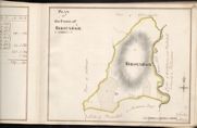
| Name: | Tait, John, ca. 1752-1782 (surveyor) Udny, Joseph, fl. ca 1770-1828 (draughtsman) | |
| Title: | Plan of the Farm of Birscaback | |
| Imprint: | 1760 | |
| Zoom Into Map: | Click on the map to view in greater detail. | |
| Field | Content | |
|---|---|---|
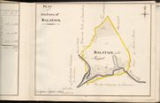
| Name: | Tait, John, ca. 1752-1782 (surveyor) Udny, Joseph, fl. ca 1770-1828 (draughtsman) | |
| Title: | Plan of the Farm of Balstack | |
| Imprint: | 1760 | |
| Zoom Into Map: | Click on the map to view in greater detail. | |
| Field | Content | |
|---|---|---|
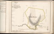
| Name: | Tait, John, ca. 1752-1782 (surveyor) Udny, Joseph, fl. ca 1770-1828 (draughtsman) | |
| Title: | Plan of the Farm of Corrie Mains | |
| Imprint: | 1760 | |
| Zoom Into Map: | Click on the map to view in greater detail. | |
| Field | Content | |
|---|---|---|
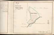
| Name: | Tait, John, ca. 1752-1782 (surveyor) Udny, Joseph, fl. ca 1770-1828 (draughtsman) | |
| Title: | Plan of the Farm Troutbeck | |
| Imprint: | 1760 | |
| Zoom Into Map: | Click on the map to view in greater detail. | |
| Field | Content | |
|---|---|---|
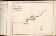
| Name: | Tait, John, ca. 1752-1782 (surveyor) Udny, Joseph, fl. ca 1770-1828 (draughtsman) | |
| Title: | Plan of the Farm of Corrie Mill | |
| Imprint: | 1760 | |
| Zoom Into Map: | Click on the map to view in greater detail. | |
| Field | Content | |
|---|---|---|
| Name: | Tait, John, ca. 1752-1782 (surveyor) Udny, Joseph, fl. ca 1770-1828 (draughtsman) | |
| Title: | Plan of the Farm of Wyneholm | |
| Imprint: | 1760 | |
| Zoom Into Map: | Click on the map to view in greater detail. | |
| Field | Content | |
|---|---|---|
| Name: | Tait, John, ca. 1752-1782 (surveyor) Udny, Joseph, fl. ca 1770-1828 (draughtsman) | |
| Title: | Plan of the Farm of Whiteriggs | |
| Imprint: | 1760 | |
| Zoom Into Map: | Click on the map to view in greater detail. | |
| Field | Content | |
|---|---|---|
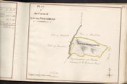
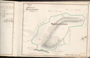
| Name: | Tait, John, ca. 1752-1782 (surveyor) Udny, Joseph, fl. ca 1770-1828 (draughtsman) | |
| Title: | Plan of the Farm of White-castles | |
| Imprint: | 1760 | |
| Zoom Into Map: | Click on the map to view in greater detail. | |
| Field | Content | |
|---|---|---|
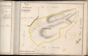
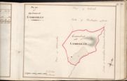
| Name: | Tait, John, ca. 1752-1782 (surveyor) Udny, Joseph, fl. ca 1770-1828 (draughtsman) | |
| Title: | Plan of the Farm of Lambhills | |
| Imprint: | 1760? | |
| Zoom Into Map: | Click on the map to view in greater detail. | |
| Field | Content | |
|---|---|---|
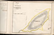
| Name: | Tait, John (fl. ca 1752-1782) | |
| Title: | Plan of Haregills | |
| Imprint: | 1762 | |
| Zoom Into Map: | Click on the map to view in greater detail. | |
| Field | Content | |
|---|---|---|
| Name: | Tait, John, ca. 1752-1782? (surveyor) Udny, Joseph, fl. ca 1770-1828 (draughtsman) | |
| Title: | Corsua & Moat | |
| Imprint: | 1767? | |
| Zoom Into Map: | Click on the map to view in greater detail. | |
| Field | Content | |
|---|---|---|
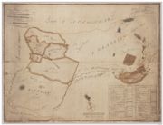
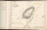
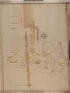
| Name: | Tait, John (fl. ca 1752-1782) | |
| Title: | Plan of Kirkconnell Mains belonging to James Maxwell of Kirkconnell, with table of contents of Kirkconnell Estate | |
| Imprint: | [1782] | |
| Zoom Into Map: | Click on the map to view in greater detail. | |

| Field | Content | |
|---|---|---|
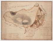
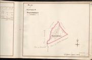
| Name: | Tait, John (fl. ca 1752-1782) | |
| Title: | Plan of Greenmerse Farm, with table of contents | |
| Imprint: | [1782] | |
| Zoom Into Map: | Click on the map to view in greater detail. | |
| Field | Content | |
|---|---|---|
| Name: | Tait, John, ca. 1752-1782, Joseph Udney | |
| Title: | Plan of the Farm of Kinnelhead and Whiteholm | |
| Imprint: | 1823 | |
| Zoom Into Map: | Click on the map to view in greater detail. | |