Mapmakers
Your search for Smith, John returned 10 records.
Ordered chronologically (undated items first).
| Field | Content | |
|---|---|---|
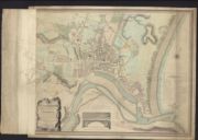
| Name: | Smith, John, | |
| Title: | Plan of the city of Aberdeen and its improvements, with the wet and dry docks and other works connected with the harbour ... to the designs of Thomas Telford ... / by John Smith. [S.J. Neele sculpt.] | |
| Imprint: | [S.l.], 1810. | |
| Zoom Into Map: | Click on the map to view in greater detail. | |
| Field | Content | |
|---|---|---|
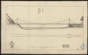
| Name: | Smith, John | |
| Title: | Plan of Suspension Bridge over the Tweed at Dryburgh. Signed: John Smith. 1820 | |
| Imprint: | 1820 | |
| Zoom Into Map: | Click on the map to view in greater detail. | |
| Field | Content | |
|---|---|---|
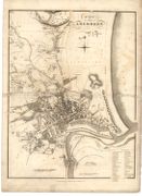
| Name: | Wood, John, ca. 1780-1847 Smith, John, 1781-1852 | |
| Title: | Plan of the Cities of Aberdeen. | |
| Imprint: | Edinburgh : [J. Wood], 1828. | |
| Zoom Into Map: | Click on the map to view in greater detail. | |
| Field | Content | |
|---|---|---|
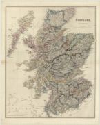
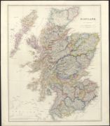
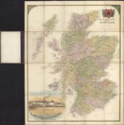
| Name: | Arrowsmith, John, 1790-1873 | |
| Title: | Scotland. | |
| Imprint: | London : J. Arrowsmith, 1846 | |
| Zoom Into Map: | Click on the map to view in greater detail. | |
| Field | Content | |
|---|---|---|
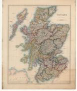
| Name: | Arrowsmith, John, 1790-1873 | |
| Title: | Scotland / by J. Arrowsmith. | |
| Imprint: | London : J Arrowsmith, 1846. | |
| Zoom Into Map: | Click on the map to view in greater detail. | |
| Field | Content | |
|---|---|---|
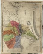
| Name: | Ogg, Alexander (land surveyor) Smith, John (architect) | |
| Title: | Map of new and old Aberdeen corrected to 1847 : with the recent improvements, railways, harbour &c. | |
| Imprint: | [Aberdeen] : D. Wyllie & Son, 111 Union Street, Aberdeen, June 21 1847. | |
| Zoom Into Map: | Click on the map to view in greater detail. | |
| Field | Content | |
|---|---|---|
| Name: | Arrowsmith, John, 1790-1873. | |
| Title: | Scotland / by J. Arrowsmith. | |
| Imprint: | London : E. Stanford, 1875 | |
| Zoom Into Map: | Click on the map to view in greater detail. | |
| Field | Content | |
|---|---|---|
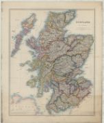
| Name: | Arrowsmith, John, 1790-1873 | |
| Title: | Scotland. | |
| Imprint: | London : E. Stanford, 1875. | |
| Zoom Into Map: | Click on the map to view in greater detail. | |
| Field | Content | |
|---|---|---|
| Name: | Arrowsmith, John, 1790-1873 | |
| Title: | W. & J. Mutter's map of Scotland / by J. Arrowsmith. | |
| Imprint: | Glasgow : W & J Mutter, [ca. 1875?] | |
| Zoom Into Map: | Click on the map to view in greater detail. | |
| Field | Content | |
|---|---|---|
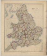
| Name: | Arrowsmith, John, 1790-1873. | |
| Title: | England / by J. Arrowsmith. | |
| Imprint: | London : E. Stanford, 1876. | |
| Zoom Into Map: | Click on the map to view in greater detail. | |