Mapmakers
Your search for Robertson, James returned 7 records.
Ordered chronologically (undated items first).
| Field | Content | |
|---|---|---|
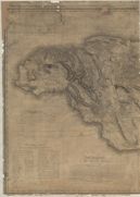
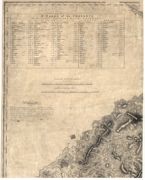
| Name: | Robertson, James, 1753-1829 | |
| Title: | this map of the island of Jamaica - West sheet | |
| Imprint: | London : J. Robertson, 1804 | |
| Zoom Into Map: | Click on the map to view in greater detail. | |
| Field | Content | |
|---|---|---|
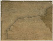
| Name: | Robertson, James, 1753-1829 | |
| Title: | this map of the county of Cornwall, in the island of Jamaica - North-West sheet | |
| Imprint: | London : J. Robertson, 1804 | |
| Zoom Into Map: | Click on the map to view in greater detail. | |
| Field | Content | |
|---|---|---|
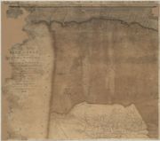
| Name: | Robertson, James, 1753-1829 | |
| Title: | ...this map of the county of Middlesex, in the island of Jamaica - North-West sheet | |
| Imprint: | London : J. Robertson, 1804 | |
| Zoom Into Map: | Click on the map to view in greater detail. | |
| Field | Content | |
|---|---|---|
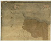
| Name: | Robertson, James, 1753-1829 | |
| Title: | ...this map of the county of Surrey, in the island of Jamaica - North-West sheet | |
| Imprint: | London : J. Robertson, 1804 | |
| Zoom Into Map: | Click on the map to view in greater detail. | |
| Field | Content | |
|---|---|---|
| Name: | Robertson, James, fl. 1810-1829 | |
| Title: | Topographical and military map of the counties of Aberdeen, Banff and Kincardine. | |
| Subtitle: | North-west sheet | |
| Imprint: | London : s.n., 1822. | |
| Zoom Into Map: | Click on the map to view in greater detail. | |
| Field | Content | |
|---|---|---|
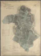
| Name: | Robertson, James | |
| Title: | Reduced plan of the hill grounds of the Estate of Ochtertyre belonging to Sir P. Murray brt. 1828. | |
| Imprint: | 1828 | |
| Zoom Into Map: | Click on the map to view in greater detail. | |
| Field | Content | |
|---|---|---|
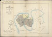
| Name: | Robertson, James | |
| Title: | Plan of the Longford Misk colliery, and part of the lands of Snodgrass 1820. Outlines of Misk taken from an old plan made in 1796. | |
| Imprint: | Edinburgh : W Peck & Son [1841] | |
| Zoom Into Map: | Click on the map to view in greater detail. | |