Mapmakers
Your search for Phinn, Thomas returned 3 records.
Ordered chronologically (undated items first).
| Field | Content | |
|---|---|---|
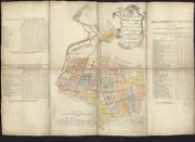
| Name: | Phinn, Thomas | |
| Title: | Plan of the Fields of Inveresk as distinguished by the valuators and division of the same among the several heritors…[1756]. | |
| Imprint: | [1756] | |
| Zoom Into Map: | Click on the map to view in greater detail. | |
| Field | Content | |
|---|---|---|
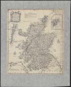
| Name: | Phinn, Thomas | |
| Title: | A new and accurate map of Scotland : drawn from surveys and the most approved maps & charts and regulated by Astron[omical] observations in which are delineated the routes of the several armies in 1745 & 1746 and the Pr[ince]s secret course by land and wa | |
| Imprint: | [Edinburgh : Printed by Sands Brymer Murray and Cochran, 1758] | |
| Zoom Into Map: | Click on the map to view in greater detail. | |
| Field | Content | |
|---|---|---|
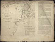
| Name: | Phinn, Thomas | |
| Title: | A survey of the River Findhorn with the fishing places & c.[1758] [with] Explanation of the Plan, signed Pet. May Surveyor.Alex Dunbar.James Russel. | |
| Imprint: | 1758 | |
| Zoom Into Map: | Click on the map to view in greater detail. | |