Mapmakers
Your search for Otter returned 13 records.
Ordered chronologically (undated items first).
| Field | Content | |
|---|---|---|
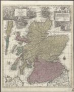
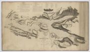
| Name: | Lotter, Tobias Conrad. | |
| Title: | Nova et Accurata totius Regni Scotiae, secundum omnes provincias et adjacentes insulas ... / delineatio, cura et sumtibus Tobiae Conradi Lotteri ... (And. Silbereÿsen sculps.). | |
| Imprint: | Aug. Vind., [1765] | |
| Zoom Into Map: | Click on the map to view in greater detail. | |
| Field | Content | |
|---|---|---|
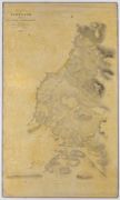
| Name: | Slater, Michael Otter, Henry C. | |
| Title: | Map of the East Coast of Scotland. Sheet XXII. Dornoch Frith by Commanders Slater and Otter, R. N. | |
| Imprint: | 1837 | |
| Zoom Into Map: | Click on the map to view in greater detail. | |
| Field | Content | |
|---|---|---|
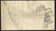
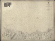
| Name: | Otter, Henry C. Slater, Michael | |
| Title: | Firth of Dornoch. Otter and Slater, 1845. | |
| Imprint: | 1845 | |
| Zoom Into Map: | Click on the map to view in greater detail. | |
| Field | Content | |
|---|---|---|
| Name: | Slater, Michael Otter, Henry C. | |
| Title: | Hydrographic Survey: Scotland. East Coast. Banff to the Ord of Caithness, Slater and Otter, 1845. | |
| Imprint: | 1845 | |
| Zoom Into Map: | Click on the map to view in greater detail. | |
| Field | Content | |
|---|---|---|
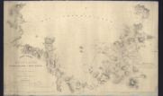
| Name: | Otter, Henry C. | |
| Title: | Hydrographic Survey: West Coast of Scotland. Handa Island to Rhu Stoir. Otter, 1846. | |
| Imprint: | 1846 | |
| Zoom Into Map: | Click on the map to view in greater detail. | |
| Field | Content | |
|---|---|---|
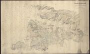
| Name: | Smith and Otter | |
| Title: | Hydrographic Survey: Loch Laxford. Smith and Otter, 1846. | |
| Imprint: | 1846 | |
| Zoom Into Map: | Click on the map to view in greater detail. | |
| Field | Content | |
|---|---|---|
| Name: | Robinson, C.G. Otter, Henry C. Bedford | |
| Title: | Hydrographic Survey: Scotland. West Coast. Robinsin, Otter and Bedford, etc. 1846-65. | |
| Imprint: | 1846-65 | |
| Zoom Into Map: | Click on the map to view in greater detail. | |
| Field | Content | |
|---|---|---|
| Name: | Otter, Henry C. | |
| Title: | West Coast of Scotland: Handa Island to Rhu Stoir by Commander H.C. Otter... 1846 | |
| Imprint: | Surveyed: 1846 | |
| Zoom Into Map: | Click on the map to view in greater detail. | |
| Field | Content | |
|---|---|---|
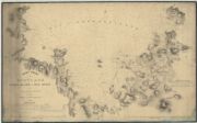
| Name: | Otter, Henry C. | |
| Title: | West Coast of Scotland. Sheet IV. Including Lochs Cairn Bahn, Glen Coul, and Glen Dhu by Commander H.C. Otter, 1846. | |
| Imprint: | Surveyed: 1846 | |
| Zoom Into Map: | Click on the map to view in greater detail. | |
| Field | Content | |
|---|---|---|
| Name: | Jeffery, James Otter, Henry C. | |
| Title: | West Coast of Scotland. Sheet 1. Croc Huish to Karra Garrow, James Jeffrey, 1848. | |
| Imprint: | Surveyed: 1848 | |
| Zoom Into Map: | Click on the map to view in greater detail. | |
| Field | Content | |
|---|---|---|
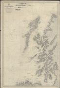
| Name: | Otter, Henry C. | |
| Title: | Scotland. North Coast. Sheet VI. Thurso to Cape Wrath. Surveyed by Commander Otter.1844, corrections to 1857. Published 1862. | |
| Imprint: | 1862 | |
| Zoom Into Map: | Click on the map to view in greater detail. | |
| Field | Content | |
|---|---|---|
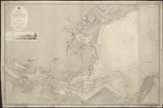
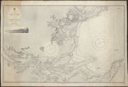
| Name: | Otter, Henry C. Slater, Michael | |
| Title: | The Firth of Dornoch, 1845. Inset: Dunrobin Castle from the Eastward | |
| Date: | 1867 | |
| Zoom Into Map: | Click on the map to view in greater detail. | |
| Field | Content | |
|---|---|---|
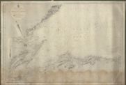
| Name: | Otter, Henry C. | |
| Title: | North Coast of Scotland : Thurso Bay to the North Minch, including parts of Orkney and Lewis, with Sule Skerry, Rona and Sula Sgeir / surveyed by Commander H.C. Otter, 1844 and 1850 ... [et al.] 1897. | |
| Imprint: | London : The Admiralty 1897-1950 | |
| Zoom Into Map: | Click on the map to view in greater detail. | |