Mapmakers
Your search for Moll, Herman returned 49 records.
Ordered chronologically (undated items first).
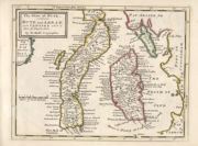
| Field | Content | |
|---|---|---|
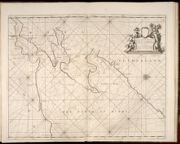
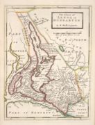
| Name: | Collins, Greenvile, fl. 1669-1698 Moll, Herman, d. 1732 | |
| Title: | The Firth of Murry / H. Moll, sculp. | |
| Imprint: | [London? : F. Collins?, 1689] | |
| Zoom Into Map: | Click on the map to view in greater detail. | |
| Field | Content | |
|---|---|---|
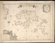
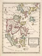
| Name: | Collins, Greenvile, fl. 1669-1698 Moll, Herman, d. 1732. | |
| Title: | The Islands of Orkney / H. Moll, sculp. | |
| Imprint: | [London? : F. Collins?, 1693?] | |
| Zoom Into Map: | Click on the map to view in greater detail. | |
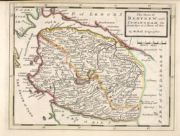
| Field | Content | |
|---|---|---|
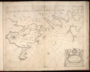
| Name: | Collins, Greenvile, fl. 1669-1698 Moll, Herman, d. 1732. | |
| Title: | Part of the Maine Island of Shetland / H. Moll, sculp. | |
| Imprint: | [London? : F. Collins?, 1693?] | |
| Zoom Into Map: | Click on the map to view in greater detail. | |
| Field | Content | |
|---|---|---|
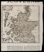
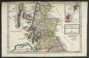
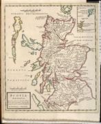
| Name: | Moll, Herman, d. 1732 | |
| Title: | Scotland. | |
| Imprint: | [London: Moll, 1701] | |
| Zoom Into Map: | Click on the map to view in greater detail. | |
| Field | Content | |
|---|---|---|
| Name: | Moll, Herman, d. 1732. | |
| Title: | The North Part of Great Britain / by Hermann Moll. | |
| Imprint: | [London : Rhodes, Nicholson and Bell, 1708] | |
| Zoom Into Map: | Click on the map to view in greater detail. | |
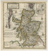
| Field | Content | |
|---|---|---|
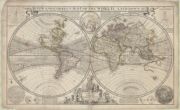
| Name: | Moll, Herman, d. 1732 | |
| Title: | A New and Correct Map of the World : , laid down ac-cording to the newest discoveries, and from the most exact observations | |
| Imprint: | [London] : H.Moll, D.Midwinter, Ri.Davies, 1709 | |
| Zoom Into Map: | Click on the map to view in greater detail. | |
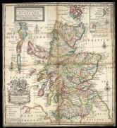
| Field | Content | |
|---|---|---|
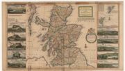
| Name: | Moll, Herman, d. 1732. | |
| Title: | The north part of Great Britain called Scotland : with considerable inprovements [sic] and many remarks not extant in any map. / According to the newest and exact observations by Hermann Moll. | |
| Imprint: | [London] : H. Moll, I. Bowles and T. Bowles, [originally published 1714, this edition ca. 1726?]. | |
| Zoom Into Map: | Click on the map to view in greater detail. | |
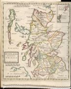
| Field | Content | |
|---|---|---|
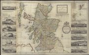
| Name: | Moll, Herman, d. 1732 | |
| Title: | The north part of Great Britain called Scotland : with considerable inprovements [sic] and many remarks not extant in any map. / According to the newest and exact observations by Hermann Moll. | |
| Imprint: | [London] : printed for H Moll and D Midwinter 1714. | |
| Zoom Into Map: | Click on the map to view in greater detail. | |
| Field | Content | |
|---|---|---|
| Name: | Moll, Herman, d. 1732 | |
| Title: | A pocket companion of ye roads of ye North part of Great Britain called Scotland ... / by Herman Moll. | |
| Imprint: | [London], 1718. | |
| Zoom Into Map: | Click on the map to view in greater detail. | |
| Field | Content | |
|---|---|---|
| Name: | Moll, Herman, d. 1732 | |
| Title: | The north part of Great Britain called Scotland : with considerable inprovements [sic] and many remarks not extant in any map / According to the newest and exact observations by Hermann Moll. | |
| Imprint: | [London] : printed for H Moll J Bowles Tho Bowles and John King, [ca. 1730] | |
| Zoom Into Map: | Click on the map to view in greater detail. | |
| Field | Content | |
|---|---|---|
| Name: | Moll, Herman, d. 1732 | |
| Title: | A new and correct map of Scotland & the Isles, containing all ye cities, market towns, boroughs, &c. / by Herman Moll. | |
| Imprint: | Dublin. : printed and sold by Geo Grierson [1730?] | |
| Zoom Into Map: | Click on the map to view in greater detail. | |
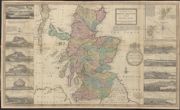
| Field | Content | |
|---|---|---|
| Name: | Moll, Herman, d. 1732 | |
| Title: | Scotland divided into its Shires / by H. Moll. | |
| Imprint: | [London : Bowles and Bowles, 1745] | |
| Zoom Into Map: | Click on the map to view in greater detail. | |

| Field | Content | |
|---|---|---|
| Name: | Moll, Herman, d. 1732 | |
| Title: | Anandale : is Part of Dumfreis Shire. Eusdale or Eskdale and Liddesdale is the South Part of Roxburgh Sh. / H. Moll. | |
| Imprint: | [London : Bowles and Bowles, 1745] | |
| Zoom Into Map: | Click on the map to view in greater detail. | |
| Field | Content | |
|---|---|---|
| Name: | Moll, Herman, d. 1732 | |
| Title: | Argyle : Lorn, Knapdale, and Cowal. All parts of Argyle Shire / by H. Moll. | |
| Imprint: | [London : Bowles and Bowles, 1745] | |
| Zoom Into Map: | Click on the map to view in greater detail. | |
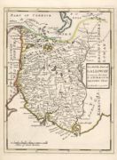
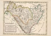
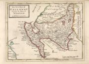
| Field | Content | |
|---|---|---|
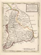
| Name: | Moll, Herman, d. 1732 | |
| Title: | The East Part of Galloway : being Part of the Shire of Kirkcudbright / by H. Moll. | |
| Imprint: | [London : Bowles and Bowles, 1745] | |
| Zoom Into Map: | Click on the map to view in greater detail. | |
| Field | Content | |
|---|---|---|
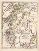
| Name: | Moll, Herman, d. 1732 | |
| Title: | The East Part of the Shire of Inverness with Badenoch &c. / by H. Moll. | |
| Imprint: | [London : Bowles and Bowles, 1745] | |
| Zoom Into Map: | Click on the map to view in greater detail. | |
| Field | Content | |
|---|---|---|
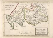
| Name: | Moll, Herman, d. 1732 | |
| Title: | Galloway : Contains The Shires of Wigton and Kirkcudbright / Her. Moll. | |
| Imprint: | [London : Bowles and Bowles, 1745] | |
| Zoom Into Map: | Click on the map to view in greater detail. | |
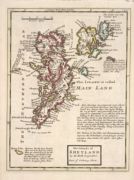
| Field | Content | |
|---|---|---|
| Name: | Moll, Herman, d. 1732 | |
| Title: | The Islands of Shetland / by H. Moll. | |
| Imprint: | [London : Bowles and Bowles, 1745] | |
| Zoom Into Map: | Click on the map to view in greater detail. | |
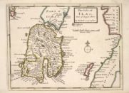
| Field | Content | |
|---|---|---|
| Name: | Moll, Herman, d. 1732 | |
| Title: | The Isle of Ila &c. Part of Argyle Shire / by H. Moll. | |
| Imprint: | [London : Bowles and Bowles, 1745] | |
| Zoom Into Map: | Click on the map to view in greater detail. | |
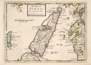
| Field | Content | |
|---|---|---|
| Name: | Moll, Herman, d. 1732 | |
| Title: | The Isle of Iura &c. Part of Argyle Shire / by H. Moll. | |
| Imprint: | [London : Bowles and Bowles, 1745] | |
| Zoom Into Map: | Click on the map to view in greater detail. | |
| Field | Content | |
|---|---|---|
| Name: | Moll, Herman, d. 1732 | |
| Title: | The Isle of Mull &c. Part of Argyle Shire / by H. Moll. | |
| Imprint: | [London : Bowles and Bowles, 1745] | |
| Zoom Into Map: | Click on the map to view in greater detail. | |
| Field | Content | |
|---|---|---|
| Name: | Moll, Herman, d. 1732 | |
| Title: | Lothian : contains The Shire of Linlithgow or West Lothian. The Shire of Edinburgh or Midlothian. and Haddington or East Lothian / by H. Moll. | |
| Imprint: | [London : Bowles and Bowles, 1745] | |
| Zoom Into Map: | Click on the map to view in greater detail. | |
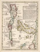
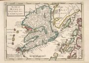
| Field | Content | |
|---|---|---|
| Name: | Moll, Herman, d. 1732 | |
| Title: | A Map of the North West part of the Western Islands / by H. Moll. | |
| Imprint: | [London : Bowles and Bowles, 1745] | |
| Zoom Into Map: | Click on the map to view in greater detail. | |
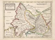
| Field | Content | |
|---|---|---|
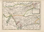
| Name: | Moll, Herman, d. 1732 | |
| Title: | The Middle Part of Galloway : Contains The West P. of Kirkcudbright Shire / by H. Moll. | |
| Imprint: | [London : Bowles and Bowles, 1745] | |
| Zoom Into Map: | Click on the map to view in greater detail. | |
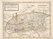
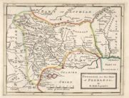
| Field | Content | |
|---|---|---|
| Name: | Moll, Herman, d. 1732 | |
| Title: | The North P. of Perth Shire containing Athol and Broadalbin / by H. Moll. | |
| Imprint: | [London : Bowles and Bowles, 1745] | |
| Zoom Into Map: | Click on the map to view in greater detail. | |
| Field | Content | |
|---|---|---|
| Name: | Moll, Herman, d. 1732 | |
| Title: | Orkney Shire / by H. Moll. | |
| Imprint: | [London : Bowles and Bowles, 1745] | |
| Zoom Into Map: | Click on the map to view in greater detail. | |
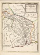
| Field | Content | |
|---|---|---|
| Name: | Gordon, Robert, 1580-1661 Moll, Herman, d. 1732 | |
| Title: | Scotia Antiqua : qualis pricis temporibus Romanis praesertim, cognita fuit quam in lucem eruere conabatur / R. Gordonius a Straloch. | |
| Imprint: | [London : Bowles and Bowles, 1745] | |
| Zoom Into Map: | Click on the map to view in greater detail. | |
| Field | Content | |
|---|---|---|
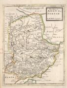
| Name: | Moll, Herman, d. 1732 | |
| Title: | The Shire of Angus or Forfar / by H. Moll. | |
| Imprint: | [London : Bowles and Bowles, 1745] | |
| Zoom Into Map: | Click on the map to view in greater detail. | |
| Field | Content | |
|---|---|---|
| Name: | Moll, Herman, d. 1732 | |
| Title: | The Shire of Berwick alias the Mers or March and Lauderdale / by H. Moll. | |
| Imprint: | [London : Bowles and Bowles, 1745] | |
| Zoom Into Map: | Click on the map to view in greater detail. | |
| Field | Content | |
|---|---|---|
| Name: | Moll, Herman, d. 1732 | |
| Title: | The Shire of Bute : contains Bute and Arran with Cantire [i.e. Kintyre] which is Part of Argyle Shire / by H. Moll. | |
| Imprint: | [London : Bowles and Bowles, 1745] | |
| Zoom Into Map: | Click on the map to view in greater detail. | |
| Field | Content | |
|---|---|---|
| Name: | Moll, Herman, d. 1732 | |
| Title: | The Shire of Clydesdale or Lanerk [i.e. Lanark] / by H. Moll. | |
| Imprint: | [London : Bowles and Bowles, 1745] | |
| Zoom Into Map: | Click on the map to view in greater detail. | |
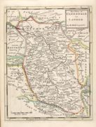
| Field | Content | |
|---|---|---|
| Name: | Moll, Herman, d. 1732 | |
| Title: | The Shire of Dumfries or Nithisdale / by H. Moll. | |
| Imprint: | [London : Bowles and Bowles, 1745] | |
| Zoom Into Map: | Click on the map to view in greater detail. | |
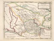
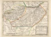
| Field | Content | |
|---|---|---|
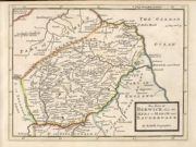
| Name: | Moll, Herman, d. 1732 | |
| Title: | The Shire of Kincairden or Mears with the South Part of Aberdeen Shire &c. / H. Moll. | |
| Imprint: | [London : Bowles and Bowles, 1745] | |
| Zoom Into Map: | Click on the map to view in greater detail. | |
| Field | Content | |
|---|---|---|
| Name: | Moll, Herman, d. 1732 | |
| Title: | The Shire of Lenox [i.e. Lennox] or Dunbarton / by H. Moll. | |
| Imprint: | [London : Bowles and Bowles, 1745] | |
| Zoom Into Map: | Click on the map to view in greater detail. | |
| Field | Content | |
|---|---|---|
| Name: | Moll, Herman, d. 1732 | |
| Title: | The Shire of Renfrew with Cuningham [i.e. Cunningham]. The North Part of Air [i.e. Ayr] / by H. Moll. | |
| Imprint: | [London : Bowles and Bowles, 1745] | |
| Zoom Into Map: | Click on the map to view in greater detail. | |
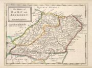
| Field | Content | |
|---|---|---|
| Name: | Moll, Herman, d. 1732 | |
| Title: | The Shires of Bamf [i.e. Banff] and Aberdeen / by H. Moll. | |
| Imprint: | [London : Bowles and Bowles, 1745] | |
| Zoom Into Map: | Click on the map to view in greater detail. | |
| Field | Content | |
|---|---|---|
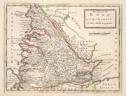
| Name: | Moll, Herman, d. 1732 | |
| Title: | The Shires of Caithness and Sutherland. With Strath Navern which is Part of Sutherland Shire / by H. Moll. | |
| Imprint: | [London : Bowles and Bowles, 1745] | |
| Zoom Into Map: | Click on the map to view in greater detail. | |
| Field | Content | |
|---|---|---|
| Name: | Moll, Herman, d. 1732 | |
| Title: | The Shires of Fife and Kinros / by H. Moll. | |
| Imprint: | [London : Bowles and Bowles, 1745] | |
| Zoom Into Map: | Click on the map to view in greater detail. | |
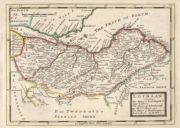
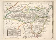
| Field | Content | |
|---|---|---|
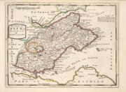
| Name: | Moll, Herman, d. 1732 | |
| Title: | The Shires of Murray and Nairn / by H. Moll. | |
| Imprint: | [London : Bowles and Bowles, 1745] | |
| Zoom Into Map: | Click on the map to view in greater detail. | |
| Field | Content | |
|---|---|---|
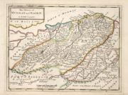
| Name: | Moll, Herman, d. 1732 | |
| Title: | The Shires of Ross, and Cromartie / by Her. Moll. | |
| Imprint: | [London : Bowles and Bowles, 1745] | |
| Zoom Into Map: | Click on the map to view in greater detail. | |
| Field | Content | |
|---|---|---|
| Name: | Moll, Herman, d. 1732 | |
| Title: | The Shires of Stirling and Clackmannan &c. / by H. Moll. | |
| Imprint: | [London : Bowles and Bowles, 1745] | |
| Zoom Into Map: | Click on the map to view in greater detail. | |
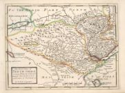
| Field | Content | |
|---|---|---|
| Name: | Moll, Herman, d. 1732 | |
| Title: | The South Part of Perth Shire Containing Perth, Strathern, Stormount and Cars of Gourie &c / by H. Moll. | |
| Imprint: | [London : Bowles and Bowles, 1745] | |
| Zoom Into Map: | Click on the map to view in greater detail. | |
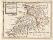
| Field | Content | |
|---|---|---|
| Name: | Moll, Herman, d. 1732 | |
| Title: | The South Part of the Shire of Air [i.e. Ayr], containing Kyle and Carrick / by H. Moll. | |
| Imprint: | [London : Bowles and Bowles, 1745] | |
| Zoom Into Map: | Click on the map to view in greater detail. | |
| Field | Content | |
|---|---|---|
| Name: | Moll, Herman, d. 1732 | |
| Title: | The North Part of ye Shire of Roxburgh and the Shire of Selkirk called also Etterick Forrest / by H. Moll. | |
| Imprint: | [London : Bowles and Bowles, 1745] | |
| Zoom Into Map: | Click on the map to view in greater detail. | |
| Field | Content | |
|---|---|---|
| Name: | Moll, Herman, d. 1732 | |
| Title: | Tweddale, alias, The Shire of Peebles &c. / by H. Moll. | |
| Imprint: | [London : Bowles and Bowles, 1745] | |
| Zoom Into Map: | Click on the map to view in greater detail. | |
| Field | Content | |
|---|---|---|
| Name: | Moll, Herman, d. 1732 | |
| Title: | The West Part of Galloway : Contains The Shire of Wigton [i.e. Wigtown] / by H. Moll. | |
| Imprint: | [London : Bowles and Bowles, 1745] | |
| Zoom Into Map: | Click on the map to view in greater detail. | |
| Field | Content | |
|---|---|---|
| Name: | Moll, Herman, d. 1732 | |
| Title: | The West Part of Inverness Sh. Lochaber with all the Territories west from it / by H. Moll. | |
| Imprint: | [London : Bowles and Bowles, 1745] | |
| Zoom Into Map: | Click on the map to view in greater detail. | |
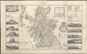
| Field | Content | |
|---|---|---|
| Name: | Moll, Herman, d. 1732 | |
| Title: | The north part of Great Britain called Scotland ... / by Herman Moll. | |
| Imprint: | Stirling : RS Shearer & Son, 1896. | |
| Zoom Into Map: | Click on the map to view in greater detail. | |
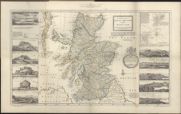
| Field | Content | |
|---|---|---|
| Name: | Moll, Herman, d. 1732 | |
| Title: | The north part of Great Britain called Scotland ... / by Herman Moll. | |
| Imprint: | Stirling : RS Shearer & Son, 1896. | |
| Zoom Into Map: | Click on the map to view in greater detail. | |