Mapmakers
Your search for Marr, John returned 5 records.
Ordered chronologically (undated items first).
| Field | Content | |
|---|---|---|
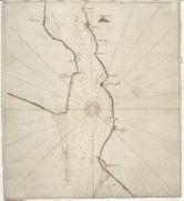
| Name: | Marr, John, fl. 1660-1720? | |
| Title: | [A chart of the mouth of the Firth of Tay]. | |
| Imprint: | [ca. 1666] | |
| Zoom Into Map: | Click on the map to view in greater detail. | |
| Field | Content | |
|---|---|---|
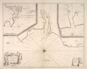
| Name: | Marr, John, fl. 1660-1720 Collins, Greenvile, fl. 1669-1698 | |
| Title: |
The Sea coast from Fiffnesse to Montros / was Survey'd by Mr. Mar, an injenious Marriner [sic] of Dundee. Sea coast from Fife Ness to Montrose. | |
| Imprint: | [London? : F. Collins?, 1693?] | |
| Zoom Into Map: | Click on the map to view in greater detail. | |
| Field | Content | |
|---|---|---|
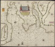
| Name: | Marr, John | |
| Title: | Nieuwe en seer perfecte paskaart van Schotlandt van Berwyk tot Bokannais = A new and pertinent map of the eastern sea-coasts of Scotland ... from the cost of Berwik till Bokaness / by John Marr of Dundee. | |
| Imprint: | [Amsterdam : Doncker ca. 1696]. | |
| Zoom Into Map: | Click on the map to view in greater detail. | |
| Field | Content | |
|---|---|---|
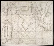
| Name: | Marr, John, fl. 1660-1720 | |
| Title: | Nieuwe en seer perfecte paskaart van Schotlandt ... van Berwyk tot Bokannais = A new and pertinent map of the eastern sea-coasts of Scotland ... from the cost of Berwik till Bokaness / by John Marr of Dundee. | |
| Imprint: | [Amsterdam : G. van Keulen, ca. 1734]. | |
| Zoom Into Map: | Click on the map to view in greater detail. | |
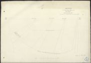
| Field | Content | |
|---|---|---|
| Name: | Marr, John | |
| Title: | Deveron, River - Sketch of Cruive Dam | |
| Imprint: | 1776 | |
| Zoom Into Map: | Click on the map to view in greater detail. | |