Mapmakers
Your search for Lewars returned 15 records.
Ordered chronologically (undated items first).
| Field | Content | |
|---|---|---|
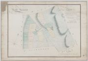
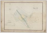
| Name: | Lewars, John, 1769-1826 | |
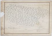
| Title: | Plan of the Farm of Whinnyhill lying in the Parish of Troqueer and Stewart: of Kirkcudbt | |
| Imprint: | 1791 | |
| Zoom Into Map: | Click on the map to view in greater detail. | |
| Field | Content | |
|---|---|---|
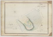
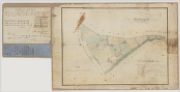
| Name: | Lewars, John, 1769-1826 | |
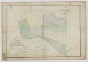
| Title: | Plan of the estate of Eccles, belonging to John Bushby Maitland | |
| Imprint: | 1801 | |
| Zoom Into Map: | Click on the map to view in greater detail. | |
| Field | Content | |
|---|---|---|
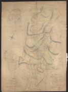
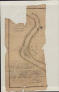
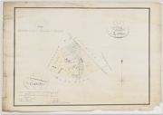
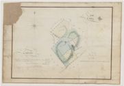
| Name: | Lewars, John, 1769-1826 | |
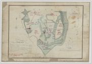
| Title: | Plan of the River Nith by John Lewars (flat map) | |
| Imprint: | 1808 | |
| Zoom Into Map: | Click on the map to view in greater detail. | |
| Field | Content | |
|---|---|---|
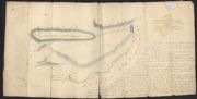
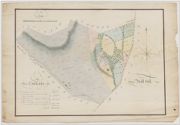
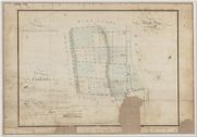
| Name: | Udny, Joseph (fl. ca 1770-1828) Lewars, John, 1769-1826 | |
| Title: | Copy of a plan made by Joseph Udny in 1792 of the commonty of Knockhill, with additions and explanations (Kirkmichael), 1814 | |
| Imprint: | 1814 | |
| Zoom Into Map: | Click on the map to view in greater detail. | |
| Field | Content | |
|---|---|---|
| Name: | Lewars, John, 1769-1826 | |
| Title: | [ A Plan of ] Meikle Auchenfad | |
| Imprint: | [1814] | |
| Zoom Into Map: | Click on the map to view in greater detail. | |
| Field | Content | |
|---|---|---|
| Name: | Lewars, John, 1769-1826 | |
| Title: | [ A Plan of ] Little Auchenfad | |
| Imprint: | [1814] | |
| Zoom Into Map: | Click on the map to view in greater detail. | |
| Field | Content | |
|---|---|---|
| Name: | Lewars, John, 1769-1826 | |
| Title: | [ A Plan of ] Loshes and Cat Aik | |
| Imprint: | 1814 | |
| Zoom Into Map: | Click on the map to view in greater detail. | |
| Field | Content | |
|---|---|---|
| Name: | Lewars, John, 1769-1826 | |
| Title: | [ A Plan of ] Mill hill | |
| Imprint: | [1814] | |
| Zoom Into Map: | Click on the map to view in greater detail. | |
| Field | Content | |
|---|---|---|
| Name: | Lewars, John, 1769-1826 | |
| Title: | [ A Plan of ] White hill | |
| Imprint: | [1814] | |
| Zoom Into Map: | Click on the map to view in greater detail. | |
| Field | Content | |
|---|---|---|
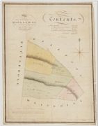
| Name: | Lewars, John, 1769-1826 Cowan, James | |
| Title: | [ A Plan of ] Martingarth [ with table of contents: July 1814, annotated 9 September 1870] | |
| Imprint: | 1814-1870 | |
| Zoom Into Map: | Click on the map to view in greater detail. | |
| Field | Content | |
|---|---|---|
| Name: | Lewars, John, 1769-1826 | |
| Title: | [ A Plan of ] Craig | |
| Imprint: | 1814 | |
| Zoom Into Map: | Click on the map to view in greater detail. | |
| Field | Content | |
|---|---|---|
| Name: | Lewars, John, 1769-1826 | |
| Title: | [ A Plan of ] Woodside [ with table of contents: July 1814, with later annotations ] | |
| Imprint: | 1814 | |
| Zoom Into Map: | Click on the map to view in greater detail. | |
| Field | Content | |
|---|---|---|
| Name: | Lewars, John, 1769-1826 | |
| Title: | [ A Plan of ] Kirkconnell Flow | |
| Imprint: | 1814 | |
| Zoom Into Map: | Click on the map to view in greater detail. | |
| Field | Content | |
|---|---|---|
| Name: | Lewars, John, 1769-1826 | |
| Title: | [ A Plan of ] Gibbon hill | |
| Imprint: | 1814 | |
| Zoom Into Map: | Click on the map to view in greater detail. | |
| Field | Content | |
|---|---|---|
| Name: | Lewars, John, 1769-1826 | |
| Title: | [ A Plan of ] Airds [ with table of contents: July] 1814, with later annotations] | |
| Imprint: | 1814 | |
| Zoom Into Map: | Click on the map to view in greater detail. | |