Mapmakers
Your search for Lauder, John returned 5 records.
Ordered chronologically (undated items first).
| Field | Content | |
|---|---|---|
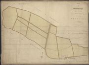
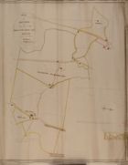
| Name: | Lauder, John. | |
| Title: | Plan of Greenknous lying in the Parish of Muiravonside in the County of Stirling. Surveyed Decr. 1800 / [by] John Louder. | |
| Imprint: | Drawn 1800. | |
| Zoom Into Map: | Click on the map to view in greater detail. | |
| Field | Content | |
|---|---|---|
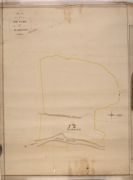
| Name: | Lauder, John | |
| Title: | Plan of the farm of Bearholm | |
| Imprint: | 1823? | |
| Zoom Into Map: | Click on the map to view in greater detail. | |
| Field | Content | |
|---|---|---|
| Name: | Lauder, John? | |
| Title: | Plan of the Common Farm | |
| Imprint: | 1823? | |
| Zoom Into Map: | Click on the map to view in greater detail. | |
| Field | Content | |
|---|---|---|
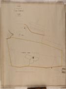
| Name: | Lauder, John? | |
| Title: | Plan of the Farm of Lochenhead and part of Whitholm | |
| Imprint: | 1823? | |
| Zoom Into Map: | Click on the map to view in greater detail. | |
| Field | Content | |
|---|---|---|
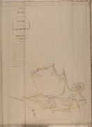
| Name: | Lauder, John? | |
| Title: | Plan of the Farms of Milton, Palaceknow and Kirktown and Redbrae | |
| Imprint: | 1823? | |
| Zoom Into Map: | Click on the map to view in greater detail. | |