Mapmakers
Your search for Gordon, Robert returned 74 records.
Ordered chronologically (undated items first).
| Field | Content | |
|---|---|---|
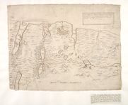
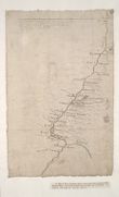
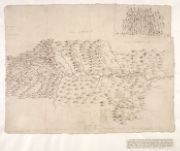
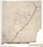
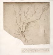
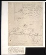
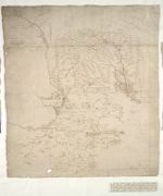
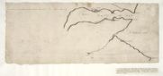
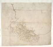
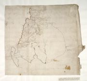
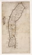
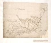
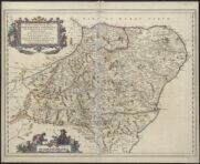
| Name: | Gordon, Robert, 1580-1661 | |
| Title: | The draught of Edera Cheules, lying betuix Strath-Navern and Assin, gathered out of Mr. Timothee Pont his papers, who travayled and descryved the same - by R. Gordon. | |
| Imprint: | 1636 | |
| Zoom Into Map: | Click on the map to view in greater detail. | |
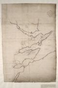
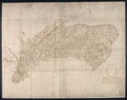
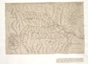
| Field | Content | |
|---|---|---|
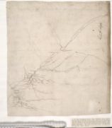
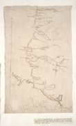
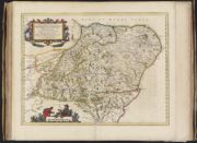
| Name: | Gordon, Robert, 1580-1661 | |
| Title: |
Part of Ros. Part of Ross. | |
| Imprint: | [ca. 1636-52] | |
| Zoom Into Map: | Click on the map to view in greater detail. | |
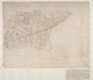
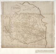
| Field | Content | |
|---|---|---|
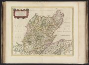
| Name: | Gordon, Robert, 1580-1661 Gordon, James, 1615?-1686. Sibbald, Robert, 1641-1722 | |
| Title: | The draught of ye river of Charron whiche falleth into the head of the firth of Tayne in Ros. from Mr. T. Pont's papers. | |
| Imprint: | [ca. 1636-52] | |
| Zoom Into Map: | Click on the map to view in greater detail. | |
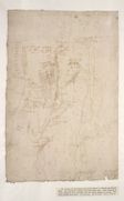
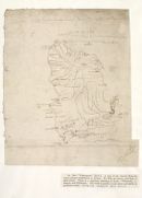
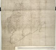
| Field | Content | |
|---|---|---|
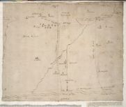
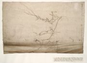
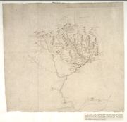
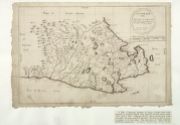
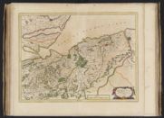
| Name: | Gordon, Robert, 1580-1661 | |
| Title: | [A map of the district from Loch Monar to Beauly and Strath Bran] | |
| Imprint: | [ca. 1636-52] | |
| Zoom Into Map: | Click on the map to view in greater detail. | |
| Field | Content | |
|---|---|---|
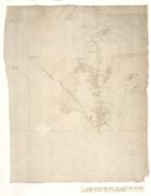
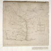
| Name: | Gordon, Robert, 1580-1661 | |
| Title: | [Map of River Findhorn down to just below the junction of the Fintack Burn] | |
| Imprint: | [ca. 1636-52] | |
| Zoom Into Map: | Click on the map to view in greater detail. | |
| Field | Content | |
|---|---|---|
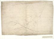
| Name: | Gordon, Robert, 1580-1661 | |
| Title: | [Map of River Avon ... ] | |
| Imprint: | [ca. 1636-52] | |
| Zoom Into Map: | Click on the map to view in greater detail. | |
| Field | Content | |
|---|---|---|
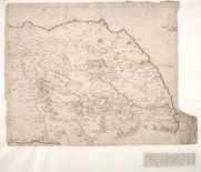
| Name: | Gordon, Robert, 1580-1661 | |
| Title: | Aberdeen, Banf [sic], Murrey [sic] &c. to Inverness : [and] Fra the north water to Ross / Robertus Gordonius a Strathloch describebat 1640. | |
| Imprint: | [ca. 1636-52] | |
| Zoom Into Map: | Click on the map to view in greater detail. | |
| Field | Content | |
|---|---|---|
| Name: | Gordon, Robert, 1580-1661 | |
| Title: | Strathbogie and Aenzie. | |
| Imprint: | [ca. 1636-52] | |
| Zoom Into Map: | Click on the map to view in greater detail. | |
| Field | Content | |
|---|---|---|
| Name: | Gordon, Robert, 1580-1661 Gordon, James, 1615?-1686 | |
| Title: |
[Strath Done] Strathdon. | |
| Imprint: | [ca. 1636-52] | |
| Zoom Into Map: | Click on the map to view in greater detail. | |
| Field | Content | |
|---|---|---|
| Name: | Gordon, Robert, 1580-1661 | |
| Title: | [A map of the district along the north side of the River Dee near Crathes and Durres, showing "Ye Lyne of Leys possession" and "Lyne of Leys clayme"] | |
| Imprint: | [ca. 1636-52] | |
| Zoom Into Map: | Click on the map to view in greater detail. | |
| Field | Content | |
|---|---|---|
| Name: | Gordon, Robert, 1580-1661 | |
| Title: | Formarten and part of Marr and Buquhan [sic] / observed R.G. | |
| Imprint: | [ca. 1636-52] | |
| Zoom Into Map: | Click on the map to view in greater detail. | |
| Field | Content | |
|---|---|---|
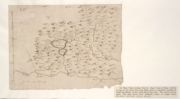
| Name: | Gordon, Robert, 1580-1661 | |
| Title: | Part of Aberdeen Shyre. | |
| Imprint: | [ca. 1636-52] | |
| Zoom Into Map: | Click on the map to view in greater detail. | |
| Field | Content | |
|---|---|---|
| Name: | Gordon, Robert, 1580-1661 | |
| Title: | [A map of the coast from the River Ythan to Inverugie] | |
| Imprint: | [ca. 1636-52] | |
| Zoom Into Map: | Click on the map to view in greater detail. | |
| Field | Content | |
|---|---|---|
| Name: | Gordon, Robert, 1580-1661 | |
| Title: |
Lochabyre. Lochaber. | |
| Imprint: | [ca. 1636-52] | |
| Zoom Into Map: | Click on the map to view in greater detail. | |
| Field | Content | |
|---|---|---|
| Name: | Gordon, Robert, 1580-1661 Gordon, James, 1615?-1686 | |
| Title: | Lower part of Bu[quhan]; Laich of Buquhan [sic]. | |
| Imprint: | [ca. 1636-52] | |
| Zoom Into Map: | Click on the map to view in greater detail. | |
| Field | Content | |
|---|---|---|
| Name: | Gordon, Robert, 1580-1661 | |
| Title: | Coygach and Loch Breyn drawn out of many imperfyt papers of M.T. Pont. | |
| Imprint: | [ca. 1636-52] | |
| Zoom Into Map: | Click on the map to view in greater detail. | |
| Field | Content | |
|---|---|---|
| Name: | Gordon, Robert, 1580-1661 | |
| Title: |
Loch Lung and Loch Dowi[...] Loch Long and Loch Duich | |
| Imprint: | [ca. 1636-52] | |
| Zoom Into Map: | Click on the map to view in greater detail. | |
| Field | Content | |
|---|---|---|
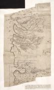
| Name: | Gordon, Robert, 1580-1661 | |
| Title: | [Map of the coast of the Moray Firth, showing Dornoch, Cromarty, and Beauly Firths] | |
| Imprint: | [ca. 1636-52] | |
| Zoom Into Map: | Click on the map to view in greater detail. | |
| Field | Content | |
|---|---|---|
| Name: | Gordon, Robert, 1580-1661 | |
| Title: |
Part of Birss [sic]. Birse. | |
| Imprint: | [ca. 1636-52] | |
| Zoom Into Map: | Click on the map to view in greater detail. | |
| Field | Content | |
|---|---|---|
| Name: | Gordon, Robert, 1580-1661 | |
| Title: | The draught of the Birs wt. the nixt parts of the river Dee. | |
| Imprint: | [ca. 1636-52] | |
| Zoom Into Map: | Click on the map to view in greater detail. | |
| Field | Content | |
|---|---|---|
| Name: | Gordon, Robert, 1580-1661 | |
| Title: |
[A map of Loch Synn, or, "Shinn", and], Assyin. M.T.P. [Loch Shin, and Assynt, Sutherland]. | |
| Imprint: | [ca. 1636-52] | |
| Zoom Into Map: | Click on the map to view in greater detail. | |
| Field | Content | |
|---|---|---|
| Name: | Gordon, Robert, 1580-1661 | |
| Title: | Coygach. | |
| Imprint: | [ca. 1636-52] | |
| Zoom Into Map: | Click on the map to view in greater detail. | |
| Field | Content | |
|---|---|---|
| Name: | Gordon, Robert, 1580-1661 | |
| Title: |
Marre from Kincairne Pueill to the Springis of Dee ; The Draught of Dee River fra Kincarne to Durris. The Draught of Dee River fra Kincarne to Durris. | |
| Imprint: | [ca. 1636-52] | |
| Zoom Into Map: | Click on the map to view in greater detail. | |
| Field | Content | |
|---|---|---|
| Name: | Gordon, Robert, 1580-1661 | |
| Title: | Anguss [sic] / R.G. | |
| Imprint: | [ca. 1636-52] | |
| Zoom Into Map: | Click on the map to view in greater detail. | |
| Field | Content | |
|---|---|---|
| Name: | Gordon, Robert, 1580-1661 | |
| Title: |
Brae of Angus, [and] The height of Anguss, M.T.P. Height of Anguss. | |
| Imprint: | [ca. 1636-52] | |
| Zoom Into Map: | Click on the map to view in greater detail. | |
| Field | Content | |
|---|---|---|
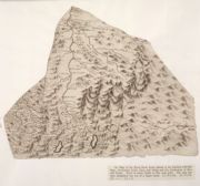
| Name: | Gordon, Robert, 1580-1661 | |
| Title: |
Glen Yla, Glen Ardle, Glen Shye, out of Mr. T. Pont's papers yey ar very imperfyt. Glen Isla, Glen Ardle, Glen Shee… | |
| Imprint: | [ca. 1636-52] | |
| Zoom Into Map: | Click on the map to view in greater detail. | |
| Field | Content | |
|---|---|---|
| Name: | Gordon, Robert, 1580-1661 | |
| Title: | [Map of North Esk River] | |
| Imprint: | [ca. 1636-52] | |
| Zoom Into Map: | Click on the map to view in greater detail. | |
| Field | Content | |
|---|---|---|
| Name: | Gordon, Robert, 1580-1661 | |
| Title: |
Mernis. Mearns. | |
| Imprint: | [ca. 1636-52] | |
| Zoom Into Map: | Click on the map to view in greater detail. | |
| Field | Content | |
|---|---|---|
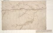
| Name: | Gordon, Robert, 1580-1661 | |
| Title: | [An outline map of the Firth of Tay and the coast to Fife-ness] | |
| Imprint: | [ca. 1636-52] | |
| Zoom Into Map: | Click on the map to view in greater detail. | |
| Field | Content | |
|---|---|---|
| Name: | Gordon, Robert, 1580-1661 | |
| Title: | [An outline map of the Tay estuary round Fife Ness and on to Kirkcaldy] | |
| Imprint: | [ca. 1636-52] | |
| Zoom Into Map: | Click on the map to view in greater detail. | |
| Field | Content | |
|---|---|---|
| Name: | Gordon, Robert, 1580-1661 | |
| Title: | Loch Lomond. | |
| Imprint: | [ca. 1636-52] | |
| Zoom Into Map: | Click on the map to view in greater detail. | |
| Field | Content | |
|---|---|---|
| Name: | Gordon, Robert, 1580-1661 | |
| Title: | Lennox, Argyle. | |
| Imprint: | [ca. 1636-52] | |
| Zoom Into Map: | Click on the map to view in greater detail. | |
| Field | Content | |
|---|---|---|
| Name: | Gordon, Robert, 1580-1661 Gordon, James, 1615?-1686 | |
| Title: |
Sterlinshyr & Lennox, [and], Sterlingshyre, wt a part of the Lennox, and sum of Clydsdail. Stirlingshire and Lennox. Stirlingshire with part of Lennox and some of Clydesdale. | |
| Imprint: | [ca. 1636-52] | |
| Zoom Into Map: | Click on the map to view in greater detail. | |
| Field | Content | |
|---|---|---|
| Name: | Gordon, Robert, 1580-1661 | |
| Title: | [A map of the basin of the River Forth, down to the widening of the estuary near Alloa]. | |
| Imprint: | [ca. 1636-52] | |
| Zoom Into Map: | Click on the map to view in greater detail. | |
| Field | Content | |
|---|---|---|
| Name: | Gordon, Robert, 1580-1661 Pont, Timothy, 1560?-1614? | |
| Title: |
Fyffe imperfect, M.T.P. : [and], Pt. of the Par. of Abyrnathy. Pt. of the Par. of Abyrnathy. Fife imperfect. Part of the parish of Abernethy | |
| Imprint: | [ca. 1636-52] | |
| Zoom Into Map: | Click on the map to view in greater detail. | |
| Field | Content | |
|---|---|---|
| Name: | Gordon, Robert, 1580-1661 | |
| Title: |
Barony of Ranfrew. Barony of Renfrew. | |
| Imprint: | [ca. 1636-52] | |
| Zoom Into Map: | Click on the map to view in greater detail. | |
| Field | Content | |
|---|---|---|
| Name: | Gordon, Robert, 1580-1661 | |
| Title: | [A map of the Clyde and Tweed basins] | |
| Imprint: | [ca. 1636-52] | |
| Zoom Into Map: | Click on the map to view in greater detail. | |
| Field | Content | |
|---|---|---|
| Name: | Gordon, Robert, 1580-1661 | |
| Title: |
The Sherifdome of Etricke Forrest with the adjoyning provinces. Ettrick Forrest wt ye joyning provinces. | |
| Imprint: | [ca. 1636-52] | |
| Zoom Into Map: | Click on the map to view in greater detail. | |
| Field | Content | |
|---|---|---|
| Name: | Gordon, Robert, 1580-1661 | |
| Title: |
A description of the province of the Merche. The Mers. | |
| Imprint: | [ca. 1636-52] | |
| Zoom Into Map: | Click on the map to view in greater detail. | |
| Field | Content | |
|---|---|---|
| Name: | Gordon, Robert, 1580-1661 | |
| Title: |
Cuningham. Cunningham. | |
| Imprint: | [ca. 1636-52] | |
| Zoom Into Map: | Click on the map to view in greater detail. | |
| Field | Content | |
|---|---|---|
| Name: | Gordon, Robert, 1580-1661 | |
| Title: |
Cuningham [sic]. Cunningham. | |
| Imprint: | [ca. 1636-52] | |
| Zoom Into Map: | Click on the map to view in greater detail. | |
| Field | Content | |
|---|---|---|
| Name: | Gordon, Robert, 1580-1661 | |
| Title: | [A map of the coast from Loch Ryan nearly to the head of Solway] | |
| Imprint: | [ca. 1636-52] | |
| Zoom Into Map: | Click on the map to view in greater detail. | |
| Field | Content | |
|---|---|---|
| Name: | Gordon, Robert, 1580-1661 | |
| Title: | [A map of the mainland of Shetland, and Fair Isle]. | |
| Imprint: | [ca. 1636-52] | |
| Zoom Into Map: | Click on the map to view in greater detail. | |
| Field | Content | |
|---|---|---|
| Name: | Gordon, Robert, 1580-1661 | |
| Title: | [A detailed map including Glenmore, Lochs Arkaig and Garry, the basins of the Nairn, Findhorn, and Spey, Lochs Ericht and Laggan, and the River Spean; also in outline Lochs Garry, Rannoch, and Tummel] | |
| Imprint: | [ca. 1636-52] | |
| Zoom Into Map: | Click on the map to view in greater detail. | |
| Field | Content | |
|---|---|---|
| Name: | Gordon, Robert, 1580-1661 | |
| Title: | [Straloch's mapp of Scotland, and, The West coast from Glen Elg to Knap-dail] | |
| Imprint: | [ca. 1636-52] | |
| Zoom Into Map: | Click on the map to view in greater detail. | |
| Field | Content | |
|---|---|---|
| Name: | Gordon, Robert, 1580-1661 | |
| Title: | [A map of Eastern Scotland, including basins of Rivers Don, Dee, Tay, Forth, and Tweed] | |
| Imprint: | [ca. 1636-52] | |
| Zoom Into Map: | Click on the map to view in greater detail. | |
| Field | Content | |
|---|---|---|
| Name: | Gordon, Robert, 1580-1661 | |
| Title: | Lochabre Glencooen / R. G. | |
| Imprint: | [ca. 1636-52] | |
| Zoom Into Map: | Click on the map to view in greater detail. | |
| Field | Content | |
|---|---|---|
| Name: | Gordon, Robert, 1580-1661 | |
| Title: |
Lochabyr. Map of Lochaber. | |
| Imprint: | [ca. 1636-52] | |
| Zoom Into Map: | Click on the map to view in greater detail. | |
| Field | Content | |
|---|---|---|
| Name: | Gordon, Robert, 1580-1661 | |
| Title: |
Cantyre. Kintyre. | |
| Imprint: | [ca. 1636-52] | |
| Zoom Into Map: | Click on the map to view in greater detail. | |
| Field | Content | |
|---|---|---|
| Name: | Gordon, Robert, 1580-1661 Gordon, James, 1615?-1686 | |
| Title: |
Athol ... and Renna... Atholl Rennach wt. all the bordering waists. | |
| Imprint: | [ca. 1636-52] | |
| Zoom Into Map: | Click on the map to view in greater detail. | |
| Field | Content | |
|---|---|---|
| Name: | Gordon, Robert, 1580-1661 | |
| Title: | [A map of Scotland, north of Glenmore in detail, and outline of the east coast to Dunbar, showing the courses of the chief rivers, and the positions of a few places] | |
| Imprint: | [ca. 1636-52] | |
| Zoom Into Map: | Click on the map to view in greater detail. | |
| Field | Content | |
|---|---|---|
| Name: | Gordon, Robert, 1580-1661 | |
| Title: | [A map of Scotland, north of Loch Linnhe and the River Dee and west of the River Deveron] | |
| Imprint: | [ca. 1636-52] | |
| Zoom Into Map: | Click on the map to view in greater detail. | |
| Field | Content | |
|---|---|---|
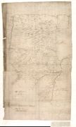
| Name: | Gordon, Robert, 1580-1661 | |
| Title: |
Sulway fyrth Liddesdale Es[kdale...] Solway Firth. | |
| Imprint: | [ca. 1636-52] | |
| Zoom Into Map: | Click on the map to view in greater detail. | |
| Field | Content | |
|---|---|---|
| Name: | Gordon, Robert, 1580-1661 | |
| Title: | [A small map of Eskdale and Liddesdale] | |
| Imprint: | [ca. 1636-52] | |
| Zoom Into Map: | Click on the map to view in greater detail. | |
| Field | Content | |
|---|---|---|
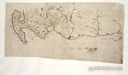
| Name: | Gordon, Robert, 1580-1661 | |
| Title: |
A description of the East coast of Scotland drawn out of Wagoner and sumqt [sic] corrected, but it not fully perfyt & yet hath many errors. Wagoners east coast of Scotland. | |
| Imprint: | [ca. 1636-52] | |
| Zoom Into Map: | Click on the map to view in greater detail. | |
| Field | Content | |
|---|---|---|
| Name: | Gordon, Robert, 1580-1661 | |
| Title: | [A Ptolemy style of map of Roman England, including part of Ireland, and showing the eastward direction of the east coast of Scotland] | |
| Imprint: | [ca. 1636-52] | |
| Zoom Into Map: | Click on the map to view in greater detail. | |
| Field | Content | |
|---|---|---|
| Name: | Gordon, Robert, 1580-1661 | |
| Title: |
Sutherland, Strath Okel & Strath Charron. Sutherland, Strath Oykel and Strathcarron. | |
| Imprint: | [ca. 1636-52] | |
| Zoom Into Map: | Click on the map to view in greater detail. | |
| Field | Content | |
|---|---|---|
| Name: | Gordon, Robert, 1580-1661 | |
| Title: | Cathenesia descripta ex magna ejusdem charta quam lustravit et descripsit Timoth. Pont. / Opera R. Gordonii ... | |
| Imprint: | mense Aprili, 1642. | |
| Zoom Into Map: | Click on the map to view in greater detail. | |
| Field | Content | |
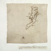
|---|---|---|
| Name: | Gordon, Robert, 1580-1661 | |
| Title: |
Nithsdail descryved according to Mr. Timothe Pont his papers / be R. Gordon. Nithsdale described … | |
| Imprint: | 1644, Mense Mai. | |
| Zoom Into Map: | Click on the map to view in greater detail. | |
| Field | Content | |
|---|---|---|
| Name: | Gordon, Robert, 1580-1661 Blaeu, Joan, 1596-1673 | |
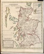
| Title: | Scotia antiqua : qualis priscis temporibus, Romanis praesertim, cognita fuit quam in lucem eruere conabatur | |
| Imprint: | Amsterdam : Blaeu, 1654 | |
| Zoom Into Map: | Click on the map to view in greater detail. | |
| Field | Content | |
|---|---|---|
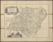
| Name: | Gordon, Robert, 1580-1661 | |
| Title: | Duo Vicecomitatus Aberdonia & Banfia ... / auctore Roberto Gordonio a Straloch. A description of the two Shyres Aberdene and Banf, etc. | |
| Imprint: | [Amsterdam, 1654] | |
| Zoom Into Map: | Click on the map to view in greater detail. | |
| Field | Content | |
|---|---|---|
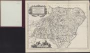
| Name: | Gordon, Robert, 1580-1661 Blaeu, Joan, 1596-1673 | |
| Title: | Duo Vicecomitatus Aberdonia & Banfia, una cum Regionibus & terrarum tractibus sub iis comprehensis / Auctore Roberto Gordonio à Straloch. Description of the two Shyres Aberdene and Banf, with such Countreys and Provinces as ar comprehended un | |
| Imprint: | [Amsterdam : Blaeu, 1654] | |
| Zoom Into Map: | Click on the map to view in greater detail. | |
| Field | Content | |
|---|---|---|
| Name: | Gordon, Robert, 1580-1661 Blaeu, Joan, 1596-1673 | |
| Title: | Extima Scotiae septentrionalis ora, ubi Provinciae sunt Rossia, Sutherlandia, Cathenesia, Strath-Naverniae, cum vicinis regiunculis quae eis subsunt, etiamque Moravia / R. Gordonius à Strath-loch collegit et descripsit. | |
| Imprint: | [Amsterdam : Blaeu, 1654] | |
| Zoom Into Map: | Click on the map to view in greater detail. | |
| Field | Content | |
|---|---|---|
| Name: | Gordon, Robert, 1580-1661 Pont, Timothy, 1560?-1614? Blaeu, Joan, 1596-1673 | |
| Title: | Moravia Scotiae provincia, ex Timothei Pont / scedis descripta et aucta per Robert: Gordonium a Strathloch. | |
| Imprint: | [Amsterdam : Blaeu, 1654] | |
| Zoom Into Map: | Click on the map to view in greater detail. | |
| Field | Content | |
|---|---|---|
| Name: | Gordon, Robert, 1580-1661 Blaeu, Joan, 1596-1673 | |
| Title: | Scotia antiqua : qualis priscis temporibus, Romanis praesertim, cognita fuit quam in lucem eruere conabatur / R. Gordonius ... | |
| Imprint: | [Amsterdam : Blaeu, 1654] | |
| Zoom Into Map: | Click on the map to view in greater detail. | |
| Field | Content | |
|---|---|---|
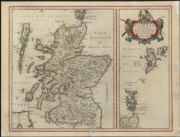
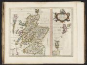
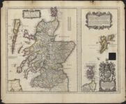
| Name: | Gordon, Robert, 1580-1661 Blaeu, Joan 1596-1673 | |
| Title: | Scotia regnum cum insulis adjacentibus / Robertus Gordonius a Straloch descripsit. | |
| Imprint: | [Amsterdam : Blaeu, 1654] | |
| Zoom Into Map: | Click on the map to view in greater detail. | |
| Field | Content | |
|---|---|---|
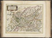
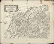
| Name: | Gordon, Robert, 1580-1661 Blaeu, Joan, 1596-1673 | |
| Title: | Scotiae provinciae mediterraneae inter Taum flumen et Vararis aestuarium : Sunt autem Braid-Allaban, Atholia, Marria Superior, Badenocha, Strath-Spea, Lochabria, cum Chersoneso qui ei ad occasum praetenditur; cum singulis earundem partibus / opera Ro. G | |
| Imprint: | [Amsterdam : Blaeu, 1654] | |
| Zoom Into Map: | Click on the map to view in greater detail. | |
| Field | Content | |
|---|---|---|
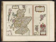
| Name: | Gordon, Robert, 1580-1661 | |
| Title: | Scotia regnum cum insulis adjacentibus / Robertus Gordonius a Straloch descripsit.. | |
| Imprint: | [London : Philip Lea, 1693]. | |
| Zoom Into Map: | Click on the map to view in greater detail. | |
| Field | Content | |
|---|---|---|
| Name: | Gordon, Robert, 1580-1661 Moll, Herman, d. 1732 | |
| Title: | Scotia Antiqua : qualis pricis temporibus Romanis praesertim, cognita fuit quam in lucem eruere conabatur / R. Gordonius a Straloch. | |
| Imprint: | [London : Bowles and Bowles, 1745] | |
| Zoom Into Map: | Click on the map to view in greater detail. | |
| Field | Content | |
|---|---|---|
| Name: | Gordon, Robert, 1580-1661 R.S. Shearer & Son | |
| Title: | Duo Vicecomitatus Aberdonia & Banfia ... / auctore Roberto Gordonio a Straloch. A description of the two Shyres Aberdene and Banf, etc. | |
| Imprint: | [N.p., late 19th century?] | |
| Zoom Into Map: | Click on the map to view in greater detail. | |
| Field | Content | |
|---|---|---|
| Name: | Gordon, Robert, 1580-1661 R.S. Shearer & Son | |
| Title: | Duo Vicecomitatus Aberdonia & Banfia = A description of the two Shyres Aberdene and Banf, etc. / auctore Roberto Gordonio a Straloch. | |
| Imprint: | Stirling : RS Shearer & Son 1891. | |
| Zoom Into Map: | Click on the map to view in greater detail. | |
| Field | Content | |
|---|---|---|
| Name: | Gordon, Robert, 1580-1661 Shearer, R.S. & Son | |
| Title: | Scotiae provinciae mediterraneae inter Taum flumen et Vararis aestuarium : Sunt autem Braid-Allaban, Atholia, Marria Superior, Badenocha, Strath-Spea, Lochabria, cum Chersoneso qui ei ad occasum praetenditur; cum singulis earundem partibus / opera Ro. G | |
| Imprint: | Stirling : R.S. Shearer & Son 1891 | |
| Zoom Into Map: | Click on the map to view in greater detail. | |
| Field | Content | |
|---|---|---|
| Name: | Gordon, Robert, 1580-1661 | |
| Title: | Scotiae Provinciae Mediterraneae inter Taum flumen et vararis aestuarium ... / opera Ro. Gordonii a Straloch, &c. | |
| Imprint: | Stirling : RS Shearer & Son, 1891. | |
| Zoom Into Map: | Click on the map to view in greater detail. | |