Mapmakers
Your search for Gordon, George returned 4 records.
Ordered chronologically (undated items first).
| Field | Content | |
|---|---|---|
| Name: | MacBey, Peter, 1821-1877 Gordon, George, 1832-1906 | |
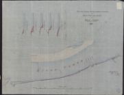
| Title: | Conon, River - Jetty showing march stones | |
| Imprint: | 1882 | |
| Zoom Into Map: | Click on the map to view in greater detail. | |
| Field | Content | |
|---|---|---|
| Name: | Gordon, George, 1832-1906 MacBey, Peter, 1821-1877 | |
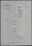
| Title: | Loch Spynie - Canal- outfall from sluice to sea | |
| Imprint: | 1888 | |
| Zoom Into Map: | Click on the map to view in greater detail. | |
| Field | Content | |
|---|---|---|
| Name: | Gordon, George & Co | |
| Title: | Plan of the Estate of Ord, the property of Major H F Mackenzie from the Ordnance Survey Revised of 1901 by Geo Gordon & Co Inverness | |
| Imprint: | 1901 | |
| Zoom Into Map: | Click on the map to view in greater detail. | |
| Field | Content | |
|---|---|---|
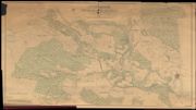
| Name: | Gordon, George & Co | |
| Title: | Lovat Estate Woods in Aird District enlarged from Six Inch Ordnace Survey by Geo Gordon & Co, Surveyors, Inverness, 1910 | |
| Imprint: | 1910 | |
| Zoom Into Map: | Click on the map to view in greater detail. | |