Mapmakers
Your search for Dunbar, William returned 24 records.
Ordered chronologically (undated items first).
| Field | Content | |
|---|---|---|
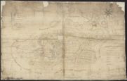
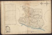
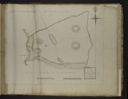
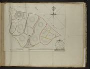
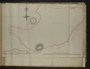
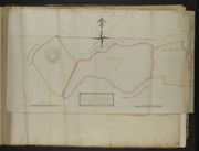
| Name: | Dunbar, William, fl. 1767-1815 | |
| Title: | A Map of the Barony of Castlestewart, Wigtownshire | |
| Imprint: | 1780 | |
| Zoom Into Map: | Click on the map to view in greater detail. | |
| Field | Content | |
|---|---|---|
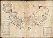
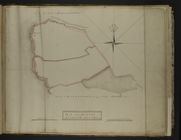
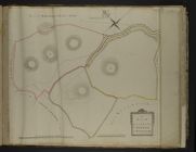
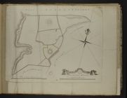
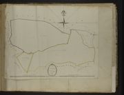
| Name: | Dunbar, William, fl. 1767-1815 | |
| Title: | Plans of the Estate of Holm in the Parish of Balmaclellan | |
| Imprint: | September 1799 | |
| Zoom Into Map: | Click on the map to view in greater detail. | |
| Field | Content | |
|---|---|---|
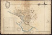
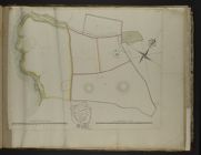
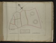
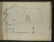
| Name: | Dunbar, William, fl. 1767-1815 | |
| Title: | A Plan of Holm | |
| Imprint: | September 1799 | |
| Zoom Into Map: | Click on the map to view in greater detail. | |
| Field | Content | |
|---|---|---|
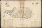
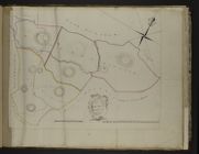
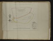
| Name: | Dunbar, William, fl. 1767-1815 | |
| Title: | A Plan of Hardland | |
| Imprint: | September 1799 | |
| Zoom Into Map: | Click on the map to view in greater detail. | |

| Field | Content | |
|---|---|---|
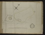
| Name: | Dunbar, William, fl. 1767-1815 | |
| Title: | A Plan of Killochy | |
| Imprint: | September 1799 | |
| Zoom Into Map: | Click on the map to view in greater detail. | |
| Field | Content | |
|---|---|---|
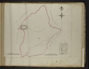
| Name: | Dunbar, William, fl. 1767-1815 | |
| Title: | A Plan of Cubbox | |
| Imprint: | September 1799 | |
| Zoom Into Map: | Click on the map to view in greater detail. | |
| Field | Content | |
|---|---|---|
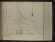
| Name: | Dunbar, William, fl. 1767-1815 | |
| Title: | Plan of the East End of South Port of Sp[ittal and Meoul - Plan 2 | |
| Subtitle: | Plan 2 | |
| Imprint: | May 1804 | |
| Zoom Into Map: | Click on the map to view in greater detail. | |
| Field | Content | |
|---|---|---|
| Name: | Dunbar, William, fl. 1767-1815 | |
| Title: | Plan of the West End of South Port of Spittal - Plan 3 | |
| Subtitle: | Plan 3 | |
| Imprint: | May 1804 | |
| Zoom Into Map: | Click on the map to view in greater detail. | |
| Field | Content | |
|---|---|---|
| Name: | Dunbar, William, fl. 1767-1815 | |
| Title: | Plan of the East End of North Port of Spittal - No.4 | |
| Subtitle: | No.4 | |
| Imprint: | May 1804 | |
| Zoom Into Map: | Click on the map to view in greater detail. | |
| Field | Content | |
|---|---|---|
| Name: | Dunbar, William, fl. 1767-1815 | |
| Title: | A Plan of the West End of North Port of Spittal, Morach and Mill Lands - No.5 | |
| Subtitle: | No.5 | |
| Imprint: | May 1804 | |
| Zoom Into Map: | Click on the map to view in greater detail. | |
| Field | Content | |
|---|---|---|
| Name: | Dunbar, William, fl. 1767-1815 | |
| Title: | A Plan of Awhirk, Birmore, Barnchilloch - Plan 6 | |
| Subtitle: | Plan 6 | |
| Imprint: | May 1804 | |
| Zoom Into Map: | Click on the map to view in greater detail. | |
| Field | Content | |
|---|---|---|
| Name: | Dunbar, William, fl. 1767-1815 | |
| Title: | A Plan of Craigoch Park, Laginmore, Big Meadow and Craigoch - Plan 7 | |
| Subtitle: | Plan 7 | |
| Imprint: | May 1804 | |
| Zoom Into Map: | Click on the map to view in greater detail. | |
| Field | Content | |
|---|---|---|
| Name: | Dunbar, William, fl. 1767-1815 | |
| Title: | Plan of High and Low Penminnoch - Plan 8 | |
| Subtitle: | Plan 8 | |
| Imprint: | May 1804 | |
| Zoom Into Map: | Click on the map to view in greater detail. | |
| Field | Content | |
|---|---|---|
| Name: | Dunbar, William, fl. 1767-1815 | |
| Title: | Plan of Dunskey and Part of Dunoin - Plan 10 | |
| Subtitle: | Plan 10 | |
| Imprint: | May 1804 | |
| Zoom Into Map: | Click on the map to view in greater detail. | |
| Field | Content | |
|---|---|---|
| Name: | Dunbar, William, fl. 1767-1815 | |
| Title: | Plan of Part of Dinvin Moor and of North Craigbovie - Plan 11 | |
| Subtitle: | Plan 11 | |
| Imprint: | May 1804 | |
| Zoom Into Map: | Click on the map to view in greater detail. | |
| Field | Content | |
|---|---|---|
| Name: | Dunbar, William, fl. 1767-1815 | |
| Title: | A Plan of Enoch North and South of the Road - Plan 12 | |
| Subtitle: | Plan 12 | |
| Imprint: | May 1804 | |
| Zoom Into Map: | Click on the map to view in greater detail. | |
| Field | Content | |
|---|---|---|
| Name: | Dunbar, William, fl. 1767-1815 | |
| Title: | A Plan of Craigenlee - Plan 13 | |
| Subtitle: | Plan 13 | |
| Imprint: | May 1804 | |
| Zoom Into Map: | Click on the map to view in greater detail. | |
| Field | Content | |
|---|---|---|
| Name: | Dunbar, William, fl. 1767-1815 | |
| Title: | A Plan of Auchenree - Plan 14 | |
| Subtitle: | Plan 14 | |
| Imprint: | May 1804 | |
| Zoom Into Map: | Click on the map to view in greater detail. | |
| Field | Content | |
|---|---|---|
| Name: | Dunbar, William, fl. 1767-1815 | |
| Title: | A Plan of Auchtree McKean - No.15 (in pencil) | |
| Subtitle: | No.15 (in pencil) | |
| Imprint: | May 1804 | |
| Zoom Into Map: | Click on the map to view in greater detail. | |
| Field | Content | |
|---|---|---|
| Name: | Dunbar, William, fl. 1767-1815 | |
| Title: | A Plan of Killantringan - Plan 16 | |
| Subtitle: | Plan 16 | |
| Imprint: | May 1804 | |
| Zoom Into Map: | Click on the map to view in greater detail. | |
| Field | Content | |
|---|---|---|
| Name: | Dunbar, William, fl. 1767-1815 | |
| Title: | A Plan of Craigslave, Moorcroft, and Craigslave Croft - | |
| Imprint: | May 1804 | |
| Zoom Into Map: | Click on the map to view in greater detail. | |
| Field | Content | |
|---|---|---|
| Name: | Dunbar, William, fl. 1767-1815 | |
| Title: | A Plan of High Tibbert, Challoch Hill and Laigh Tibbert - Plan 18 | |
| Subtitle: | Plan 18 | |
| Imprint: | May 1804 | |
| Zoom Into Map: | Click on the map to view in greater detail. | |
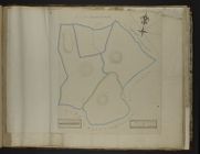
| Field | Content | |
|---|---|---|
| Name: | Dunbar, William, fl. 1767-1815 | |
| Title: | Plan of S. Knockglass and N. Knockglass - Plan 19 | |
| Subtitle: | Plan 19 | |
| Imprint: | May 1804 | |
| Zoom Into Map: | Click on the map to view in greater detail. | |
| Field | Content | |
|---|---|---|
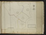
| Name: | Dunbar, William, fl. 1767-1815 | |
| Title: | A Plan of Crailoch - Plan 20 | |
| Subtitle: | Plan 20 | |
| Imprint: | May 1804 | |
| Zoom Into Map: | Click on the map to view in greater detail. | |