Mapmakers
Your search for Crawford, William returned 40 records.
Ordered chronologically (undated items first).
| Field | Content | |
|---|---|---|
| Name: | Crawford, William | |
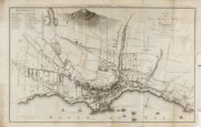
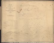
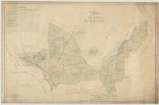
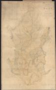
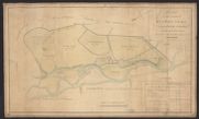
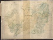
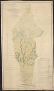
| Title: | Plan of the town, harbour & suburbs of Dundee with the adjacent country | |
| Imprint: | Dundee : Leslie, 1793 | |
| Zoom Into Map: | Click on the map to view in greater detail. | |
| Field | Content | |
|---|---|---|
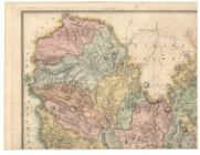
| Name: | Crawford, William, fl. 1774-1828 | |
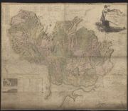
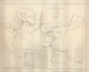
| Title: | Map of Dumfries-shire from an actual survey / by Wm. Crawford. Engraved by Kirkwood & Sons. (General View of the Mineralogy or Internal Structure of Dumfries-shire. Prepared ... by Brigr. General Dirom). | |
| Imprint: | [Edinburgh, 1804] | |
| Zoom Into Map: | Click on the map to view in greater detail. | |
| Field | Content | |
|---|---|---|
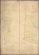
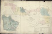
| Name: | Crawford, William, fl. 1774-1828 | |
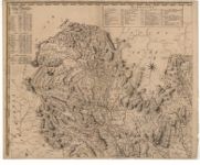
| Title: | Map of Dumfries-shire. | |
| Subtitle: | North-west sheet | |
| Imprint: | [Edinburgh : Crawford, 1804] | |
| Zoom Into Map: | Click on the map to view in greater detail. | |
| Field | Content | |
|---|---|---|
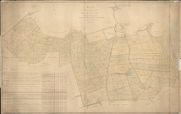
| Name: | Crawford, William & son | |
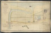
| Title: | Plan of Ground lying at Magdalene Bridge, parish of Inveresk and County of Edinburgh belonging to John Wauchope Esqr of Edmonstone. | |
| Imprint: | 1809 | |
| Zoom Into Map: | Click on the map to view in greater detail. | |
| Field | Content | |
|---|---|---|
| Name: | Crawford, William, fl. 1774-1828 Crawford, David, fl. 1802-1829 | |
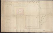
| Title: | Plan of part of the Barony of Tinwald | |
| Imprint: | 1812 | |
| Zoom Into Map: | Click on the map to view in greater detail. | |
| Field | Content | |
|---|---|---|
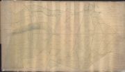
| Name: | Crawford, William, fl. 1774-1828 | |
| Title: | Sketch of Drumlanrig Castle. | |
| Imprint: | 1812 | |
| Zoom Into Map: | Click on the map to view in greater detail. | |
| Field | Content | |
|---|---|---|
| Name: | Crawford, William, fl. 1774-1828 Crawford, David, fl. 1802-1829 | |
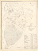
| Title: | Plan of the Barony of Mouswald in the Parishes of Mouswald & Dalton | |
| Imprint: | 1812 | |
| Zoom Into Map: | Click on the map to view in greater detail. | |
| Field | Content | |
|---|---|---|
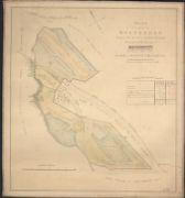
| Name: | Crawford, William, 1793-ca.1845 | |
| Title: | Plan of the estate of Dalswinton / (by W. Crawford jnr. E. Mitchell sculpt.). | |
| Imprint: | Edinburgh, 1817. | |
| Zoom Into Map: | Click on the map to view in greater detail. | |
| Field | Content | |
|---|---|---|
| Name: | Crawford, William, 1793-ca.1845 | |
| Title: | Plan of part of the Barony of Tinwald | |
| Imprint: | 1817 | |
| Zoom Into Map: | Click on the map to view in greater detail. | |
| Field | Content | |
|---|---|---|
| Name: | Crawford, William; Mitchell, E. (engraver) | |
| Title: | Plan of the Estate of Dalswinton | |
| Imprint: | 1817 | |
| Zoom Into Map: | Click on the map to view in greater detail. | |
| Field | Content | |
|---|---|---|
| Name: | Crawford, William, fl. 1774-1828 | |
| Title: | Plan of Malcomflat. | |
| Imprint: | 1818 | |
| Zoom Into Map: | Click on the map to view in greater detail. | |
| Field | Content | |
|---|---|---|
| Name: | Crawford, William, fl. 1774-1828 | |
| Title: | Sketch of the lands of Knockinstob | |
| Imprint: | 1818 | |
| Zoom Into Map: | Click on the map to view in greater detail. | |
| Field | Content | |
|---|---|---|
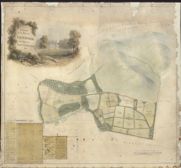
| Name: | Crawford, William, 1793-ca.1845 | |
| Title: | Plan of the estate of Newholm: 1819. | |
| Imprint: | 1819 | |
| Zoom Into Map: | Click on the map to view in greater detail. | |
| Field | Content | |
|---|---|---|
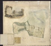
| Name: | Crawford, William, 1793-ca.1845 | |
| Title: | Plan of the estate of Newholm: 1819. | |
| Imprint: | 1819 | |
| Zoom Into Map: | Click on the map to view in greater detail. | |
| Field | Content | |
|---|---|---|
| Name: | Crawford, William, fl. 1774-1828 Crawford, David, fl. 1802-1829 | |
| Title: | Plan of farms belonging to the Duke of Buccleuch | |
| Imprint: | 1820 | |
| Zoom Into Map: | Click on the map to view in greater detail. | |
| Field | Content | |
|---|---|---|
| Name: | Crawford, William, fl. 1774-1828 Crawford, David, fl. 1802-1829 | |
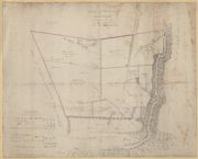
| Title: | Plan of the Barony of Craigs and part of the Barony of Tinwald in the county of Dumfries | |
| Imprint: | 1820s(?) | |
| Zoom Into Map: | Click on the map to view in greater detail. | |
| Field | Content | |
|---|---|---|
| Name: | Crawford, William, fl. 1774-1828 Crawford, David, fl. 1802-1829 | |
| Title: | Plan of the barony of Ross in the Parish of Kirkmichael | |
| Imprint: | 1820 | |
| Zoom Into Map: | Click on the map to view in greater detail. | |
| Field | Content | |
|---|---|---|
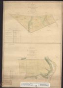
| Name: | Crawford, William, fl. 1774-1828 | |
| Title: | Plan of the farm of Croftheads; Plan of the farm of Broomhouse (Dryfesdale) | |
| Imprint: | 1821 | |
| Zoom Into Map: | Click on the map to view in greater detail. | |
| Field | Content | |
|---|---|---|
| Name: | Crawford, William, fl. 1774-1828 Crawford, David, fl. 1802-1829 | |
| Title: | Plan of the lands in the parish of Dornock belonging to His Grace the Duke of Buccleuch | |
| Imprint: | 1821 | |
| Zoom Into Map: | Click on the map to view in greater detail. | |
| Field | Content | |
|---|---|---|
| Name: | Crawford, William, fl. 1774-1828 Crawford, David, fl. 1802-1829 | |
| Title: | Plan of part of the lands in the parish of Middlebie belonging to His Grace the Duke of Buccleuch | |
| Imprint: | 1821 | |
| Zoom Into Map: | Click on the map to view in greater detail. | |
| Field | Content | |
|---|---|---|
| Name: | (Crawford, William?) | |
| Title: | Plan of the farm of Watscales in the Parish of Hutton | |
| Imprint: | 1821 | |
| Zoom Into Map: | Click on the map to view in greater detail. | |
| Field | Content | |
|---|---|---|
| Name: | Crawford, William, fl. 1774-1828 Crawford, David, fl. 1802-1829 | |
| Title: | Plan of the farm of Swinefoot lying in the Parish of Kirkpatrick Juxta | |
| Imprint: | 1821 | |
| Zoom Into Map: | Click on the map to view in greater detail. | |
| Field | Content | |
|---|---|---|
| Name: | Crawford, William, fl. 1774-1828 Crawford, David, fl. 1802-1829 | |
| Title: | Plan of the farm of Cauldholm lying in the Parish of Kirkpatrick Juxta | |
| Imprint: | 1821 | |
| Zoom Into Map: | Click on the map to view in greater detail. | |
| Field | Content | |
|---|---|---|
| Name: | Crawford, William, fl. 1774-1828 Crawford, David, fl. 1802-1829 | |
| Title: | Plan of that part of the barony of Lochhouse lying in the neighbourhood of Moffat and Parish of Kirkpatrick Juxta | |
| Imprint: | 1821 | |
| Zoom Into Map: | Click on the map to view in greater detail. | |
| Field | Content | |
|---|---|---|
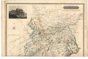
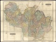
| Name: | Thomson, John, 1777- ca. 1840 Crawford, William & Son | |
| Title: | Roxburghshire. | |
| Subtitle: | Plate 4 from John Thomson's 'Atlas of Scotland', 1832 | |
| Imprint: | Edinburgh : J. Thomson & Co., 1822. | |
| Zoom Into Map: | Click on the map to view in greater detail. | |
| Field | Content | |
|---|---|---|
| Name: | Crawford, William, fl. 1774-1828 Crawford, David, fl. 1802-1829 | |
| Title: | Plan of the farm of Craigland in the Parish of Hoddam; Plan of the farm of Woodland in the Parish of Hoddam | |
| Imprint: | 1824 | |
| Zoom Into Map: | Click on the map to view in greater detail. | |
| Field | Content | |
|---|---|---|
| Name: | Crawford, William, fl. 1774-1828 Crawford, David, fl. 1802-1829 | |
| Title: | Plan of Cunningholm in the Parish of Closeburn belonging to His Grace the Duke of Buccleuch & Quensberry | |
| Imprint: | [c. 1825] | |
| Zoom Into Map: | Click on the map to view in greater detail. | |
| Field | Content | |
|---|---|---|
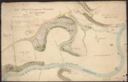
| Name: | Crawford, William, fl. 1774-1828 | |
| Title: | Sketch of a proposed plantation on Carronfoot | |
| Imprint: | 1825 | |
| Zoom Into Map: | Click on the map to view in greater detail. | |
| Field | Content | |
|---|---|---|
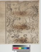
| Name: | Crawford, William, fl. 1774-1828 | |
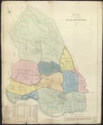
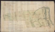
| Title: | Plan of the parish of Durisdeer. | |
| Imprint: | 1820, 1825 | |
| Zoom Into Map: | Click on the map to view in greater detail. | |
| Field | Content | |
|---|---|---|
| Name: | Crawford, William, fl. 1774-1828 Crawford, David, fl. 1802-1829 | |
| Title: | Plan of the farms of Porterstown, Penmurtie and Beuchan in the Parish of Keir | |
| Imprint: | 1825 | |
| Zoom Into Map: | Click on the map to view in greater detail. | |
| Field | Content | |
|---|---|---|
| Name: | Crawford, William, fl. 1774-1828 | |
| Title: | Reduced Plan of the farms of Porterstown, Penmurtie and Beuchan in the Parish of Keir | |
| Imprint: | 1825 | |
| Zoom Into Map: | Click on the map to view in greater detail. | |
| Field | Content | |
|---|---|---|
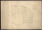
| Name: | Crawford, William, fl. 1774-1828 | |
| Title: | Plan of the farms of Barndinnoch, Fardingjames, Kirkbride and Breco in the Parish of Keir | |
| Imprint: | 1825 | |
| Zoom Into Map: | Click on the map to view in greater detail. | |
| Field | Content | |
|---|---|---|
| Name: | Crawford, William, fl. 1774-1828 | |
| Title: | Reduced Plan of Penfillan in the Parish of Keir | |
| Imprint: | 1825 | |
| Zoom Into Map: | Click on the map to view in greater detail. | |
| Field | Content | |
|---|---|---|
| Name: | Crawford, William Jnr., ca 1793-1845 | |
| Title: | Plan of the estates of Colebrooke in the Parishes of Crawford and Crawfordjohn | |
| Imprint: | 1826 | |
| Zoom Into Map: | Click on the map to view in greater detail. | |
| Field | Content | |
|---|---|---|
| Name: | Crawford, William | |
| Title: | Plan of the estate of Newtondon, lying in the parishes of Ednam, Newthorn & Smailholm and counties of Roxburgh and Berwick 1828 / William Crawford surveyor. | |
| Imprint: | Edinburgh : A Forrester lithog 1828. | |
| Zoom Into Map: | Click on the map to view in greater detail. | |
| Field | Content | |
|---|---|---|
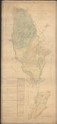
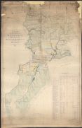
| Name: | Crawford, William, fl. 1774-1828 Crawford & Son | |
| Title: | [Dumfriesshire] / surveyed by Crawford & Son, for the Atlas of Scotland. | |
| Imprint: | Edinburgh : John Thomson, 1828. | |
| Zoom Into Map: | Click on the map to view in greater detail. | |
| Field | Content | |
|---|---|---|
| Name: | Thomson, John, 1777- ca. 1840 Crawford, William & Son | |
| Title: | Dumfriesshire. | |
| Subtitle: | Plate 6 from John Thomson's 'Atlas of Scotland', 1832. North-west sheet | |
| Imprint: | Edinburgh : J. Thomson & Co., 1828. | |
| Zoom Into Map: | Click on the map to view in greater detail. | |
| Field | Content | |
|---|---|---|
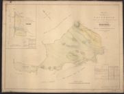
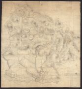
| Name: | Crawford, William, fl. 1774-1828 | |
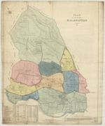
| Title: | Plan of the parish of Sanquhar, the property of His Grace the Duke of Buccleuch and Queensberry | |
| Imprint: | 1831 | |
| Zoom Into Map: | Click on the map to view in greater detail. | |
| Field | Content | |
|---|---|---|
| Name: | Crawford, William, fl. 1774-1828 | |
| Title: | Sketch of the Lands in the Parish of Sanquhar north of Nith | |
| Imprint: | 1831 | |
| Zoom Into Map: | Click on the map to view in greater detail. | |
| Field | Content | |
|---|---|---|
| Name: | Crawford, William, 1793-ca.1845 Brooke, William, fl. 1835-47. | |
| Title: | Map embracing extensive portions of the Counties of Roxburgh, Berwick, Selkirk & Midlothian and Part of Northumberland. Minutely & accurately surveyed… by Crawford and Brooke | |
| Imprint: | W. Forrester : Edinburgh, [1843] | |
| Zoom Into Map: | Click on the map to view in greater detail. | |