Mapmakers
Your search for Cooper, Richard returned 11 records.
Ordered chronologically (undated items first).
| Field | Content | |
|---|---|---|
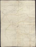
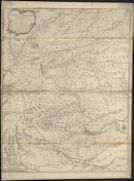
| Name: | Cooper, Richard, 1705-1764 | |
| Title: | A Skitch [sic] of part of the Highlands of Scotland. | |
| Imprint: | [ca. 170-?]. | |
| Zoom Into Map: | Click on the map to view in greater detail. | |
| Field | Content | |
|---|---|---|
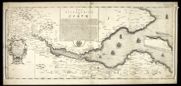
| Name: | Adair, John, ca. 1650-1722 Cooper, Richard, 1705-1764 | |
| Title: | The River and Frith [sic] of Forth ... / Richard Cooper sculpt. | |
| Imprint: | Edinburgh : Cooper, 1730. | |
| Zoom Into Map: | Click on the map to view in greater detail. | |
| Field | Content | |
|---|---|---|
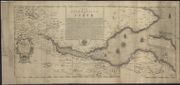
| Name: | Cooper, Richard, c. 1705-1764 | |
| Title: | The River and Frith [sic] of Forth ... / Richard Cooper sculpt. | |
| Imprint: | Edinburgh : Cooper 1730. | |
| Zoom Into Map: | Click on the map to view in greater detail. | |
| Field | Content | |
|---|---|---|
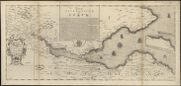
| Name: | Adair, John, ca. 1650-1722 Cooper, Richard | |
| Title: | The River and Frith [sic] of Forth ... / Richard Cooper sculpt. | |
| Imprint: | Edinburgh : Cooper 1730. | |
| Zoom Into Map: | Click on the map to view in greater detail. | |

| Field | Content | |
|---|---|---|
| Name: | Bruce, Alexander, fl. 1706 Cooper, Richard, 1705-1764. | |
| Title: | A plan of Loch Sunart … become famous by the greatest national improvement this age has produc'd / survey'd &c. by Alexr. Bruce ; R. Cooper sculp. | |
| Imprint: | [Edinburgh : Bruce, 1733] | |
| Zoom Into Map: | Click on the map to view in greater detail. | |
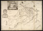
| Field | Content | |
|---|---|---|
| Name: | Adair, John, ca. 1650-1722 Cooper, Richard, 1705-1764 | |
| Title: | A Map of Midlothian / survey'd by Mr. J. Adair. | |
| Imprint: | [Edinburgh : Cooper, ca. 1735] | |
| Zoom Into Map: | Click on the map to view in greater detail. | |
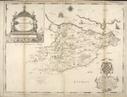
| Field | Content | |
|---|---|---|
| Name: | Adair, John, ca. 1650-1722 Cooper, Richard, 1705-1764 | |
| Title: | A Map of West Lothian / survey'd by Mr. J. Adair. | |
| Imprint: | [Edinburgh : Cooper, ca. 1737] | |
| Zoom Into Map: | Click on the map to view in greater detail. | |
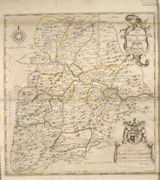
| Field | Content | |
|---|---|---|
| Name: | Edgar, William, fl. 1717-1746 Cooper, Richard, 1705-1764 | |
| Title: | A new and correct map of the Shire of Peebles or Tweeddale / survey'd by Will. Edgar, 1741 ; R. Cooper sculp. | |
| Imprint: | [Edinburgh? : s.n.], 1741. | |
| Zoom Into Map: | Click on the map to view in greater detail. | |
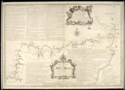
| Field | Content | |
|---|---|---|
| Name: | Bryce, Alexander fl. ca. 1744 Cooper, Richard, 1705-1764 | |
| Title: | A Map of the North Coast of Britain, from Row Stoir of Assynt, to Wick in Caithness : By a Geometrical Survey with the Harbours, Rocks, & an Account of the Tides in the Pentland Firth, done at the Philosophical Society at Edinburgh / R. Cooper sculpt. | |
| Imprint: | [Edinburgh : s.n., 1744] | |
| Zoom Into Map: | Click on the map to view in greater detail. | |
| Field | Content | |
|---|---|---|
| Name: | Cooper, Richard, c. 1705-1764 | |
| Title: | A map of His Majesty's roads from Edinburgh to Inverness, Fort Augustus & Fort William and of the countries adjacent thereto ... dedicated to ... William Augustus, Duke of Cumberland ... / by ... Richd. Cooper. (R. Cooper sculpt.). | |
| Imprint: | [Edinburgh, 1746] | |
| Zoom Into Map: | Click on the map to view in greater detail. | |
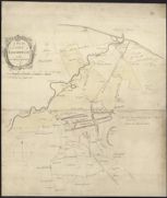
| Field | Content | |
|---|---|---|
| Name: | Cooper, Richard, c. 1705-1764 | |
| Title: | A plan of the city of Edinburgh with the adjacent grounds / [engraved by Richard Cooper] | |
| Imprint: | [Edinburgh, 1759] | |
| Zoom Into Map: | Click on the map to view in greater detail. | |