Mapmakers
Your search for Buchanan returned 13 records.
Ordered chronologically (undated items first).
| Field | Content | |
|---|---|---|
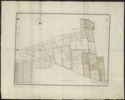
| Name: | Buchanan, George. | |
| Title: | Plan of the estate of Ingliston belonging to James Gibson Craig ... / (drawn by Geo. Buchanan). | |
| Imprint: | [Edinburgh, ca. 1828] | |
| Zoom Into Map: | Click on the map to view in greater detail. | |
| Field | Content | |
|---|---|---|
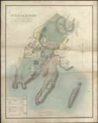
| Name: | Buchanan, George, 1790-1852 | |
| Title: | Castleton and Cottage Parks. | |
| Imprint: | 1830 | |
| Zoom Into Map: | Click on the map to view in greater detail. | |
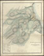
| Field | Content | |
|---|---|---|
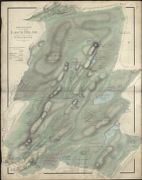
| Name: | Buchanan, George, 1790-1852 | |
| Title: | East Division of the Farm of Lochhead and Achachoish. | |
| Imprint: | 1830 | |
| Zoom Into Map: | Click on the map to view in greater detail. | |
| Field | Content | |
|---|---|---|
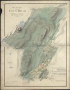
| Name: | Buchanan, George, 1790-1852 | |
| Title: | West Division of the Farm of Lochhead and Achachoish. | |
| Imprint: | 1830 | |
| Zoom Into Map: | Click on the map to view in greater detail. | |
| Field | Content | |
|---|---|---|
| Name: | Buchanan, George, 1790-1852 | |
| Title: | Stronachullen and Strondour. | |
| Imprint: | 1831 | |
| Zoom Into Map: | Click on the map to view in greater detail. | |
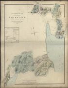
| Field | Content | |
|---|---|---|
| Name: | Buchanan, George, 1790-1852 | |
| Title: | General Plan of the Estate of Shirvane belonging to John Grahame Campbell… | |
| Imprint: | 1831 | |
| Zoom Into Map: | Click on the map to view in greater detail. | |
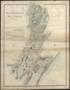
| Field | Content | |
|---|---|---|
| Name: | Buchanan, George, 1790-1852 | |
| Title: | Silver Craigs and Ballimore including Castleton &c. | |
| Imprint: | 1831 | |
| Zoom Into Map: | Click on the map to view in greater detail. | |
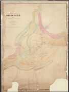
| Field | Content | |
|---|---|---|
| Name: | Buchanan, George, 1790-1852 | |
| Title: | No. 1 Plan of the Lower Boundaries of the River Nith, with the Channels and Banks thereof at Low Water | |
| Imprint: | 1836 | |
| Zoom Into Map: | Click on the map to view in greater detail. | |
| Field | Content | |
|---|---|---|
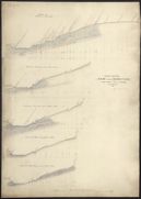
| Name: | Buchanan, George, 1790?-1852 | |
| Title: | Edinburgh - Cross sections of the bank behind Moray Place from Water of Leith to Building. 1837. George Buchanan. | |
| Imprint: | 1837 | |
| Zoom Into Map: | Click on the map to view in greater detail. | |
| Field | Content | |
|---|---|---|
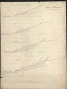
| Name: | Buchanan, George, 1790?-1852 | |
| Title: | Edinburgh - Cross sections of the bank behind Moray Place from Water of Leith to Building. 1837. George Buchanan. | |
| Imprint: | 1837 | |
| Zoom Into Map: | Click on the map to view in greater detail. | |
| Field | Content | |
|---|---|---|
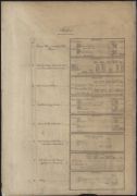
| Name: | Buchanan, George, 1790-1852 | |
| Title: | Six estate maps of Shirvan, Argyll, with contemporary index. | |
| Imprint: | 1836-41 ? | |
| Zoom Into Map: | Click on the map to view in greater detail. | |
| Field | Content | |
|---|---|---|
| Name: | Buchanan, George, 1790-1852 | |
| Title: | Plan of the estate of Craigentinny. | |
| Imprint: | Edinburgh : Schenck, 1847. | |
| Zoom Into Map: | Click on the map to view in greater detail. | |
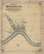
| Field | Content | |
|---|---|---|
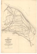
| Name: | Tudor, E. G. Buchanan. | |
| Title: | Plan of the town and port of Goole. Compiled from authentic sources and actual survey. showing the River Ouse Improvement scheme, new docks & locks ... / by E.G. Buchanan Tudor and Colin A.B. Tudor. | |
| Imprint: | [Goole, 1874] | |
| Zoom Into Map: | Click on the map to view in greater detail. | |