Mapmakers
Your search for Brown, John returned 5 records.
Ordered chronologically (undated items first).
| Field | Content | |
|---|---|---|
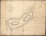
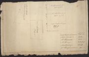
| Name: | Brown, John, fl. 1803-1832 | |
| Title: | Plan of the Lands of Barend and Killie Crookie | |
| Imprint: | March 20, 1805 | |
| Zoom Into Map: | Click on the map to view in greater detail. | |
| Field | Content | |
|---|---|---|
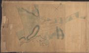
| Name: | Brown, John, fl. 1803-1832 | |
| Title: | Castle Douglas | |
| Imprint: | October 1811 | |
| Zoom Into Map: | Click on the map to view in greater detail. | |
| Field | Content | |
|---|---|---|
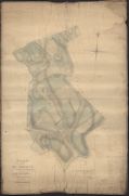
| Name: | Brown, John, fl. 1803-1832 | |
| Title: | Plan of the Lands of Blackerne in the Parish of Cross Michael and of Leaths in the Parish of Buittle | |
| Imprint: | July 1814 | |
| Zoom Into Map: | Click on the map to view in greater detail. | |
| Field | Content | |
|---|---|---|
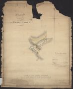
| Name: | Brown, John, fl. 1803-1832 | |
| Title: | Plan of Part of the Village of Auchencairn | |
| Imprint: | October 1815 | |
| Zoom Into Map: | Click on the map to view in greater detail. | |
| Field | Content | |
|---|---|---|
| Name: | Brown, John, fl. 1803-1832 | |
| Title: | Auchencairn (showing houses) | |
| Imprint: | 1815 | |
| Zoom Into Map: | Click on the map to view in greater detail. | |