Mapmakers
Your search for Blackadder, John returned 7 records.
Ordered chronologically (undated items first).
| Field | Content | |
|---|---|---|
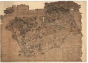
| Name: | Blackadder, John, fl. 1793-1830 | |
| Title: | Berwickshire. | |
| Imprint: | [Edinburgh] : s.n., 1797. | |
| Zoom Into Map: | Click on the map to view in greater detail. | |
| Field | Content | |
|---|---|---|
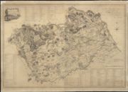
| Name: | Blackadder, John, fl. 1793-1830 | |
| Title: | Berwickshire, from actual survey / by John Blackadder. Engraved by J. Ainslie. | |
| Imprint: | [Edinburgh], 1797. | |
| Zoom Into Map: | Click on the map to view in greater detail. | |
| Field | Content | |
|---|---|---|
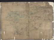
| Name: | Blackadder, John | |
| Title: | Map of Berwickshire by John Blackadder, 1797 | |
| Imprint: | 1797 | |
| Zoom Into Map: | Click on the map to view in greater detail. | |
| Field | Content | |
|---|---|---|
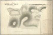
| Name: | Blackadder, John (fl. 1793-1830) | |
| Title: | Plan of Shielswood farm. | |
| Imprint: | 1829 | |
| Zoom Into Map: | Click on the map to view in greater detail. | |
| Field | Content | |
|---|---|---|
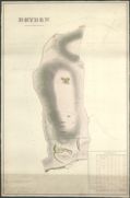
| Name: | Blackadder, John (fl. 1793-1830) | |
| Title: | Plan of Dryden farm. | |
| Imprint: | 1829 | |
| Zoom Into Map: | Click on the map to view in greater detail. | |
| Field | Content | |
|---|---|---|
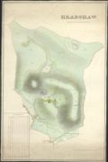
| Name: | Blackadder, John (fl. 1793-1830) | |
| Title: | Plan of Headshaw farm. | |
| Imprint: | 1829 | |
| Zoom Into Map: | Click on the map to view in greater detail. | |
| Field | Content | |
|---|---|---|
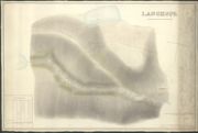
| Name: | Blackadder, John (fl. 1793-1830) Wilson, Thomas | |
| Title: | Langhope…by John Blackadder, 1830, after an original plan measured by Thomas Wilson, 1767 | |
| Imprint: | 1830 (1767) | |
| Zoom Into Map: | Click on the map to view in greater detail. | |