Mapmakers
Your search for Adair, John returned 53 records.
Ordered chronologically (undated items first).
| Field | Content | |
|---|---|---|
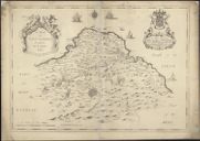
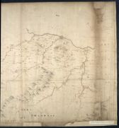
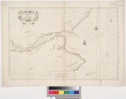
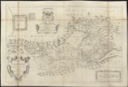
| Name: | Adair, John, ca. 1650-1722 | |
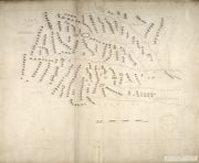
| Title: | A map of East Lothian / survey'd by J. Adair . | |
| Imprint: | [Edinburgh : Cooper ca. 1736] | |
| Zoom Into Map: | Click on the map to view in greater detail. | |
| Field | Content | |
|---|---|---|
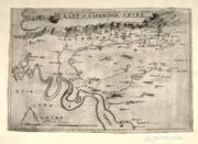
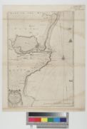
| Name: | Adair, John, ca. 1650-1722 | |
| Title: |
A Mapp of Clakmanan Shire. A map of Clackmannanshire. | |
| Imprint: | [ca. 1681] | |
| Zoom Into Map: | Click on the map to view in greater detail. | |
| Field | Content | |
|---|---|---|
| Name: | Adair, John, ca. 1650-1722 | |
| Title: | [A map of Strath Devon and the district between the Ochils and the Forth] | |
| Imprint: | [1681] | |
| Zoom Into Map: | Click on the map to view in greater detail. | |
| Field | Content | |
|---|---|---|
| Name: | Adair, John, ca. 1650-1722 | |
| Title: | East Lothian / authore Johanne Adair. | |
| Imprint: | 1682. | |
| Zoom Into Map: | Click on the map to view in greater detail. | |
| Field | Content | |
|---|---|---|
| Name: | Adair, John, ca. 1650-1722 | |
| Title: | [Map of Midlothian] | |
| Imprint: | [ca. 1682?] | |
| Zoom Into Map: | Click on the map to view in greater detail. | |
| Field | Content | |
|---|---|---|
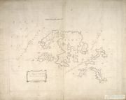
| Name: | Adair, John, ca. 1650-1722 | |
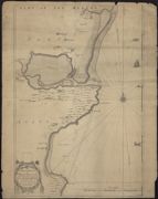
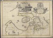
| Title: | The Mappe of Orkney with the harbours and Islands. | |
| Imprint: | 1682. | |
| Zoom Into Map: | Click on the map to view in greater detail. | |
| Field | Content | |
|---|---|---|
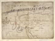
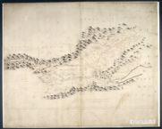
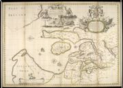
| Name: | Adair, John, ca. 1650-1722 | |
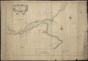
| Title: | The Mappe of Straithern, Stormont, & Cars of Gourie with the rivers Tay and Ern / surveighed & designed [by] John Adair. | |
| Imprint: | 1683. | |
| Zoom Into Map: | Click on the map to view in greater detail. | |
| Field | Content | |
|---|---|---|
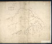
| Name: | Adair, John, ca. 1650-1722 | |
| Title: | The Hydrographicall mappe of Forth from the entry to ye Queens-ferry / authore Jo. Adair. | |
| Imprint: | [1683] | |
| Zoom Into Map: | Click on the map to view in greater detail. | |
| Field | Content | |
|---|---|---|
| Name: | Adair, John, ca. 1650-1722 | |
| Title: | The East Part of Fife / surveyed & designed be [i.e. by] John Adair. | |
| Imprint: | 1684. | |
| Zoom Into Map: | Click on the map to view in greater detail. | |
| Field | Content | |
|---|---|---|
| Name: | Adair, John, ca. 1650-1722 | |
| Title: | Mappe of Wast Lothian comonly called Linlithgowshire / authore Johanne Adair. | |
| Imprint: | [1684] | |
| Zoom Into Map: | Click on the map to view in greater detail. | |
| Field | Content | |
|---|---|---|
| Name: | Adair, John, ca. 1650-1722 | |
| Title: | A Mape of the countries about Stirling / authore Jo. Adair. | |
| Imprint: | [168-?] | |
| Zoom Into Map: | Click on the map to view in greater detail. | |
| Field | Content | |
|---|---|---|
| Name: | Adair, John, ca. 1650-1722 | |
| Title: | A mape of the west of Scotland containing Clydsdail, Nithsdail, Ranfrew, Shyre of Ayre, & Galloway / authore Jo. Adair. | |
| Imprint: | [1685] | |
| Zoom Into Map: | Click on the map to view in greater detail. | |
| Field | Content | |
|---|---|---|
| Name: | Adair, John, ca. 1650-1722 | |
| Title: | The Sherifdome of Etrik Forest. | |
| Imprint: | [ca. 1688] | |
| Zoom Into Map: | Click on the map to view in greater detail. | |
| Field | Content | |
|---|---|---|
| Name: | Adair, John, ca. 1650-1722 | |
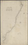
| Title: | A true and exact Hydrographical description of the Sea coast and Isles of Scotland made in Voyage round the same by that great and mighty James the 5th. [First] published at Paris by Nicholay D'aulphinois, 1583, and at Edinburgh, by John Adair | |
| Imprint: | [Edinburgh : s.n., 1703] | |
| Zoom Into Map: | Click on the map to view in greater detail. | |
| Field | Content | |
|---|---|---|
| Name: | Adair, John, ca. 1650-1722 | |
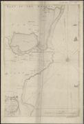
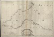
| Title: | The Frith of Forth from the Entry to the Queen's ferry, with all the Islands, Rocks, Sands, &c. | |
| Imprint: | [Edinburgh : s.n., 1703] | |
| Zoom Into Map: | Click on the map to view in greater detail. | |
| Field | Content | |
|---|---|---|
| Name: | Adair, John, ca. 1650-1722 | |
| Title: | Holy-Island, Fairn Islands with the many Rocks and Hazards that lye Scatter'd in that Sea, and the Coast from Sunderland point in England to St Abbs-head in Scotland, survey'd and navigated by J[oh]n Adair | |
| Imprint: | [Edinburgh : s.n., 1703] | |
| Zoom Into Map: | Click on the map to view in greater detail. | |
| Field | Content | |
|---|---|---|
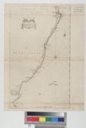
| Name: | Adair, John, ca. 1650-1722 | |
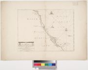
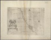
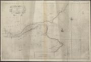
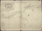
| Title: | The Frith and River of Tay with all the Rocks, Sands, Shoals, &c., Survey'd by John Adair | |
| Imprint: | [Edinburgh : s.n., 1703] | |
| Zoom Into Map: | Click on the map to view in greater detail. | |
| Field | Content | |
|---|---|---|
| Name: | Adair, John, ca. 1650-1722 | |
| Title: | The Town and Water of Montross with the neighbouring Country & Coast from the Red-head to the North-water. Survey'd and Navigated by John Adair. | |
| Imprint: | [Edinburgh : s.n., 1703] | |
| Zoom Into Map: | Click on the map to view in greater detail. | |
| Field | Content | |
|---|---|---|
| Name: | Adair, John, ca. 1650-1722 | |
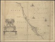
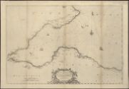
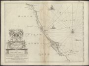
| Title: | The coast of Scotland from the Red-head to Aberdeen. Survey'd by John Adair. | |
| Imprint: | [Edinburgh : s.n., 1703] | |
| Zoom Into Map: | Click on the map to view in greater detail. | |
| Field | Content | |
|---|---|---|
| Name: | Adair, John, ca. 1650-1722 | |
| Title: | Holy-Island, Fairn-Islands ... and the Coast from Sunderland point ... to St. Abbs-head ... / surveyed and navigated by Jo. Adair (Ja. Clark sculp.). | |
| Imprint: | [Edinburgh, 1703] | |
| Zoom Into Map: | Click on the map to view in greater detail. | |
| Field | Content | |
|---|---|---|
| Name: | Adair, John, ca. 1650-1722 | |
| Title: | The towne & water of Montross, with the neighbouring country & coast ... / surveyed & navigated be John Adair, 1693. (Ja. Clark sculp.). | |
| Imprint: | [Edinburgh, 1703] | |
| Zoom Into Map: | Click on the map to view in greater detail. | |
| Field | Content | |
|---|---|---|
| Name: | Adair, John, ca. 1650-1722 | |
| Title: | The Frith and River of Tay ... / survey'd by John Adair. (Ja. Clark sculp.). | |
| Imprint: | [Edinburgh, 1703] | |
| Zoom Into Map: | Click on the map to view in greater detail. | |
| Field | Content | |
|---|---|---|
| Name: | Adair, John, ca. 1650-1722 | |
| Title: | Holy-Island, Fairn-Islands ... and the Coast from Sunderland point ... to St. Abbs-head ... / surveyed and navigat'd by Jo. Adair. (Ja. Clark sculp.). | |
| Imprint: | [Edinburgh, 1703] | |
| Zoom Into Map: | Click on the map to view in greater detail. | |

| Field | Content | |
|---|---|---|
| Name: | Adair, John, ca. 1650-1722 | |
| Title: | A true and exact hydrographical description of the sea-coast and Isles of Scotland ... / published at Paris by Nicolay D'aulphinois ... 1583, and at Edinburgh by John Adair ... 1688. (James Moxon sculp.). | |
| Imprint: | [Edinburgh: Adair 1703] | |
| Zoom Into Map: | Click on the map to view in greater detail. | |
| Field | Content | |
|---|---|---|
| Name: | Adair, John, ca. 1650-1722 | |
| Title: | The coast of Scotland from the Red-head to Aberdeen / surveyed by John Adair. (Ja. Clark sculp.). | |
| Imprint: | [Edinburgh, 1703] | |
| Zoom Into Map: | Click on the map to view in greater detail. | |
| Field | Content | |
|---|---|---|
| Name: | Adair, John, ca. 1650-1722 | |
| Title: | The towne & water of Montross, with the neighbouring country & coast ... / surveyed & navigated be John Adair, 1693. (Ja. Clark sculp.). | |
| Imprint: | [Edinburgh, 1703] | |
| Zoom Into Map: | Click on the map to view in greater detail. | |
| Field | Content | |
|---|---|---|
| Name: | Adair, John, ca. 1650-1722 | |
| Title: | The Frith and River of Tay ... / survey'd by John Adair. (Ja. Clark sculp.). | |
| Imprint: | [Edinburgh, 1703] | |
| Zoom Into Map: | Click on the map to view in greater detail. | |
| Field | Content | |
|---|---|---|
| Name: | Adair, John, ca. 1650-1722 | |
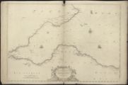
| Title: | The Frith of Forth from the entry to the Queens ferry... / surveyed by John Adair. | |
| Imprint: | [Edinburgh, 1703] | |
| Zoom Into Map: | Click on the map to view in greater detail. | |
| Field | Content | |
|---|---|---|
| Name: | Adair, John, ca. 1650-1722 | |
| Title: | The Frith of Forth from the entry to the Queens ferry... / surveyed by John Adair. | |
| Imprint: | [Edinburgh, 1703] | |
| Zoom Into Map: | Click on the map to view in greater detail. | |
| Field | Content | |
|---|---|---|
| Name: | Adair, John, ca. 1650-1722 | |
| Title: | The Frith and River of Tay with all the Rocks, Sands, Shoals, &c. | |
| Imprint: | [ca. 1703] | |
| Zoom Into Map: | Click on the map to view in greater detail. | |
| Field | Content | |
|---|---|---|
| Name: | Adair, John, ca. 1650-1722 | |
| Title: | The Frith of Forth from the entry to the Queens ferry, with all the Islands, Rocks, Sands | |
| Imprint: | [ca. 1703] | |
| Zoom Into Map: | Click on the map to view in greater detail. | |
| Field | Content | |
|---|---|---|
| Name: | Adair, John, ca. 1650-1722 | |
| Title: | Holy-Island, Fairn-Islands ... and the Coast from Sunderland point ... to St. Abbs-head ... / surveyed and navigat'd by Jo. Adair. (Ja. Clark sculp.). | |
| Imprint: | [Edinburgh, 1703] | |
| Zoom Into Map: | Click on the map to view in greater detail. | |
| Field | Content | |
|---|---|---|
| Name: | Adair, John, ca. 1650-1722 | |
| Title: | The Frith of Forth from the entry to the Queens ferry... / surveyed by John Adair. | |
| Imprint: | [Edinburgh, 1703] | |
| Zoom Into Map: | Click on the map to view in greater detail. | |
| Field | Content | |
|---|---|---|
| Name: | Adair, John, ca. 1650-1722 | |
| Title: | The coast of Scotland from the Red-head to Aberdeen / surveyed by John Adair. (Ja. Clark sculp.). | |
| Imprint: | [Edinburgh, 1703] | |
| Zoom Into Map: | Click on the map to view in greater detail. | |
| Field | Content | |
|---|---|---|
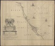
| Name: | Adair, John, ca. 1650-1722 Moxon, J. (James) fl. 1671-1700, | |
| Title: | The Mapp of Straithern, Stormount, and Cars of Gourie, with the Rivers Tay and Jern / surveighed and designed by J. Adair ; James Moxon sculp. | |
| Imprint: | [S.l. : s.n., 1720?] | |
| Zoom Into Map: | Click on the map to view in greater detail. | |
| Field | Content | |
|---|---|---|
| Name: | Adair, John, ca. 1650-1722 | |
| Title: | The Mapp of Straithern, Stormount, and Cars of Gourie, with the Rivers Tay and Jern / surveighed and designed by J. Adair ; James Moxon sculp. | |
| Imprint: | [S.l. : sn 1720?] | |
| Zoom Into Map: | Click on the map to view in greater detail. | |
| Field | Content | |
|---|---|---|
| Name: | Adair, John, ca. 1650-1722 Cooper, Richard | |
| Title: | The River and Frith [sic] of Forth ... / Richard Cooper sculpt. | |
| Imprint: | Edinburgh : Cooper 1730. | |
| Zoom Into Map: | Click on the map to view in greater detail. | |
| Field | Content | |
|---|---|---|
| Name: | Adair, John, ca. 1650-1722 Cooper, Richard, 1705-1764 | |
| Title: | The River and Frith [sic] of Forth ... / Richard Cooper sculpt. | |
| Imprint: | Edinburgh : Cooper, 1730. | |
| Zoom Into Map: | Click on the map to view in greater detail. | |
| Field | Content | |
|---|---|---|
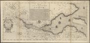
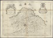
| Name: | Adair, John, ca. 1650-1722 | |
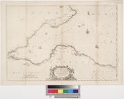
| Title: | A new and exact map of the River Clyde done by the late Mr. John Adair / now publish'd for the good of the publick by Geo. Scott. | |
| Imprint: | [S.l.] : Scott, [1731] | |
| Zoom Into Map: | Click on the map to view in greater detail. | |
| Field | Content | |
|---|---|---|
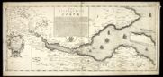
| Name: | Adair, John, ca. 1650-1722 | |
| Title: | A new and exact map of the river Clyde / done by ... John Adair ... R. Cooper sculp. | |
| Imprint: | [Edinburgh], 1731. | |
| Zoom Into Map: | Click on the map to view in greater detail. | |
| Field | Content | |
|---|---|---|
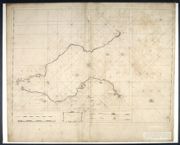
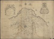
| Name: | Adair, John, ca. 1650-1722 | |
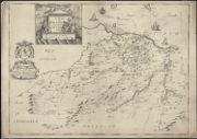
| Title: | A map of Mid-Lothian / survey'd by ... J. Adair. [Engraved by Richard Cooper] | |
| Imprint: | [Edinburgh, 1735] | |
| Zoom Into Map: | Click on the map to view in greater detail. | |
| Field | Content | |
|---|---|---|
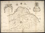
| Name: | Adair, John, ca. 1650-1722 Cooper, Richard, 1705-1764 | |
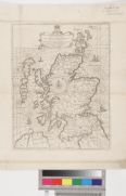
| Title: | A Map of Midlothian / survey'd by Mr. J. Adair. | |
| Imprint: | [Edinburgh : Cooper, ca. 1735] | |
| Zoom Into Map: | Click on the map to view in greater detail. | |
| Field | Content | |
|---|---|---|
| Name: | Adair, John, ca. 1650-1722 | |
| Title: | A Map of Midlothian / survey'd by Mr. J. Adair. | |
| Imprint: | [Edinburgh : Cooper, ca. 1735] | |
| Zoom Into Map: | Click on the map to view in greater detail. | |
| Field | Content | |
|---|---|---|
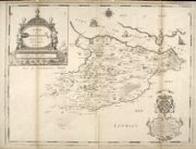
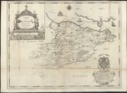
| Name: | Adair, John, ca. 1650-1722 | |
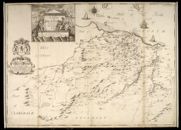
| Title: | A map of East Lothian / survey'd by J. Adair . | |
| Imprint: | [Edinburgh : Cooper, ca. 1736] | |
| Zoom Into Map: | Click on the map to view in greater detail. | |
| Field | Content | |
|---|---|---|
| Name: | Adair, John, ca. 1650-1722 | |
| Title: | A map of East Lothian / survey'd by J. Adair. | |
| Imprint: | [Edinburgh : Cooper, ca. 1736] | |
| Zoom Into Map: | Click on the map to view in greater detail. | |
| Field | Content | |
|---|---|---|
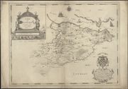
| Name: | Adair, John, ca. 1650-1722 Cooper, Richard, 1705-1764 | |
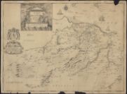
| Title: | A Map of West Lothian / survey'd by Mr. J. Adair. | |
| Imprint: | [Edinburgh : Cooper, ca. 1737] | |
| Zoom Into Map: | Click on the map to view in greater detail. | |
| Field | Content | |
|---|---|---|
| Name: | Adair, John, ca. 1650-1722 | |
| Title: | A map of West-Lothian / survey'd by Mr. J. Adair. | |
| Imprint: | [Edinburgh : Richard Cooper 1737] | |
| Zoom Into Map: | Click on the map to view in greater detail. | |
| Field | Content | |
|---|---|---|
| Name: | Adair, John, ca. 1650-1722 | |
| Title: | A map of West-Lothian / survey'd by Mr. J. Adair. | |
| Imprint: | [Edinburgh : Richard Cooper 1737] | |
| Zoom Into Map: | Click on the map to view in greater detail. | |
| Field | Content | |
|---|---|---|
| Name: | Adair, John, ca. 1650-1722 Moxon, J. R.S. Shearer & Son | |
| Title: | The mapp of Straithern, Stormount and cars of Gourie, with the rivers Tay and Jern / surveighed and designed by John Adair ... (James Moxon sculp.). | |
| Imprint: | Stirling, 1897. | |
| Zoom Into Map: | Click on the map to view in greater detail. | |
| Field | Content | |
|---|---|---|
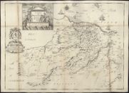
| Name: | Adair, John, ca. 1650-1722 | |
| Title: | A map of Mid-Lothian / survey'd by J. Adair. | |
| Imprint: | [Edinburgh : Cooper ca. 1736] | |
| Zoom Into Map: | Click on the map to view in greater detail. | |
| Field | Content | |
|---|---|---|
| Name: | Adair, John, ca. 1650-1722 | |
| Title: | A map of East Lothian / survey'd by J. Adair . | |
| Imprint: | [Edinburgh : Cooper ca. 1736] | |
| Zoom Into Map: | Click on the map to view in greater detail. | |