Estate maps, Jamaica
| Field | Content |
|---|---|
| Name: | Morison, Kenneth |
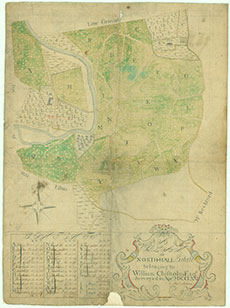
| Title: | A plan of North-Hall Estate, belonging to William Chisholm, Esq |
| Imprint: | Surveyed in April 1771 |
| Pagination: | 1 manuscript map : col. ; 548 x 405 mm. |
| Shelfmark: | Ch.5650 |
| Notes: | Scale: 5 Chains to an inch. This detailed estate plan shows the layout of a typical sugar plantation estate in Jamaica. The estate owner's house is shown to the upper right, with its Garden (b) and Park (c), the main sugar mill Works some distance away to the centre left (f), with a Cow Pen (h) to the lower right. North Hall Estate was situated in the parish of Clarendon and county of Middlesex in the south of Jamaica, six miles north of May Pen, and 30 miles west of Kingston. William Chisholm was the son of a Selkirk doctor, who trained as one himself before moving to Jamaica. He later became the owner of several sugar estates, including Thomas's River, North Hall, Health Crawl and Breadland Pen in Clarendon, Jamaica, as well as owning a quarter share of Trout Hall, Green River, Troys and Chisholm's Mammee Gully pen in Jamaica, the latter estates being mainly owned by his brother James. After William Chisholm's death in 1802, North Hall's ownership passed to his niece, Mary Agnes Sinclair (née Chisholme). The plan is held within the Business papers and accounts of William, James and Charles Chisholme of that Ilk (1747-1814), , and more specifically, the Deeds and formal papers of the Chisholmes. |
| Zoom Into Map: | Click on the map to view in greater detail. |