Map Finder - with Marker pin - Help
You can use this application to search and view all of our online maps. This search process complements our main Map Finder - with Outlines application that allows searching showing the boundaries or outlines of map sheets. Our Georeferenced Maps application allows a selection of seamless mosaics to be viewed.
Watch a Help video on the Map Finder viewer.
There are multiple zoom levels in the map viewer, but the returned maps are at just three main levels of detail / scales on the right-hand side:
- Small-scale maps - low level of detail - eg. whole countries
- Medium-scale maps - general overview of wider landscape - eg. regions / counties
- Large-scale maps - high level of detail - eg. town plans and estate maps
You can switch to set the map viewer to display just 3 zoom levels by selecting the View 3 zoom levels button (upper right).
Navigation
Go to other viewers for the same area:

Main search process


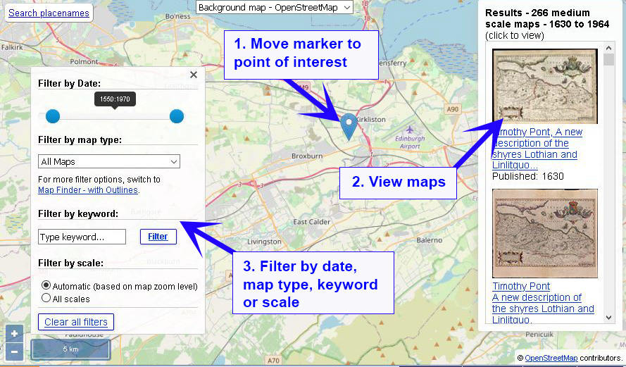
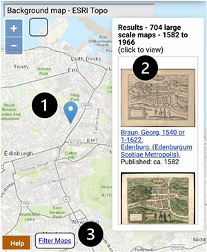
- Move the marker to your point of interest. Just click on the map to move the marker there. You can also search by placenames (upper left), and the marker and map will locate to your chosen placename.
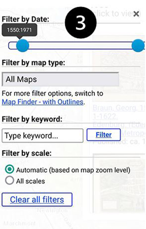
- (Optionally) filter the maps by date range, map type, keyword or scale.
- The maps covering the marker location appear in the Results on the right. Click on the map image thumbnails to view the maps.
- Move the marker to your point of interest. Just click on the map to move the marker there. You can also search by placenames (upper left), and the marker and map will locate to your chosen placename.
- The maps covering the marker location appear in the Results on the right. Click on the map image thumbnails to view the maps.
- (Optionally) filter the maps by date range, map type, keyword or scale.

All of our online maps are searched in this application.
The Gazetteer at the top of the map search panel allows you to locate your area on the map using modern place names from Nominatim, using OpenStreetMap names, as well as the Definitive Gazetteer for Scotland (PDF, 135KB), developed by Bruce M. Gittings, University of Edinburgh, with funding from the Scottish Government. The OSM Nominatim gazetteer is stronger for larger settlements and street names, as well as for its global coverage, whilst the Definitive Gazetteer for Scotland is particularly strong for smaller rural features in Scotland, such as farms and hamlets, mountains, hills, rivers, streams, and lochs. The two gazetteers are searched collectively using the OSMNames technology.
The map will then position to the place that has been selected.
Search by National Grid Reference, Latitude/Longitude or Postcode (top left)
You can search by British National Grid Reference - 2, 4, 6, 8, or 10 figures (ie. 'SE12', 'NT1234', 'TQ123456', 'SD12345678', 'SD1234567890'). You can also search using numeric Grid References as Eastings and Northings (ie. '123456,123456'), or by using latitute, longitude (ie. '52.123,-2.345').
You can also search by postcode. You can enter just the postcode area (ie. 'EH'), district (ie. 'EH9'), sector (ie. 'EH9 1'), or to the full unit (ie. 'EH9 1SL'), either with a space in the middle (ie. 'EH9 1SL') or without (ie. 'EH91SL'). This uses the Ordnance Survey Open Names API.
When you press 'Enter' or the 'Go' button, the map will then position to the National Grid Reference, latitude/longitude, or postcode that has been entered.
Search by historic counties and parishes (top left)
Further down, drop-down boxes allow counties and parishes (based on their names and boundaries in the 1940s) to be searched. When you select a county, the parishes within that county appear as a second drop-down list, allowing you to select the parish.
We gratefully acknowledge OpenStreetMap, Ordnance Survey, and Bruce M. Gittings, University of Edinburgh for allowing us to use these gazetteers, and the Vision of Britain project for allowing us to use these county and parish boundaries.
Show my location? / Geolocation (top left)
You can tick the ![]() Show my location? option in the left-hand panel, and the approximate location of your device, with a radius around it, will appear as a blue dot with a circle around it on the map if you choose to share this data with the application. This uses the W3C Geolocation API specification which provides scripted access to geographical location information associated with the user’s device, by asking the user for permission to share their location, enabling the association of the user’s IP address with the detected location.
Show my location? option in the left-hand panel, and the approximate location of your device, with a radius around it, will appear as a blue dot with a circle around it on the map if you choose to share this data with the application. This uses the W3C Geolocation API specification which provides scripted access to geographical location information associated with the user’s device, by asking the user for permission to share their location, enabling the association of the user’s IP address with the detected location.
Limit results by date range
Change the date range sliders in the left-hand panel to limit the maps returned to a particular span of years.
Limit results by scale
By default, the maps returned are based on the scale of your main map. When zoomed out, covering a wider geographic area, less detailed maps are returned. When zoomed in, covering a smaller geographic area, more detailed maps are returned. To change this to return all maps, regardless of the zoom level, change the Scales of returned maps to 'All scales' in the left-hand panel.
Printing and Image Export/Download (lower left)
If you click/tap on the print icon ![]() , to the lower left of the screen, then a print panel opens with various options:
, to the lower left of the screen, then a print panel opens with various options:
- Portrait / landscape orientation
- Page size – A4 to A0
- Margin – 0 to 10 mm
- Scale – 1:500 to 1:1,000,000 - set an exact scale for your map
- North Arrow – off or on
At this stage you can also pan/drag or zoom the map image to make sure its covering exactly the right area of interest.
You can then save the image in various formats – JPEG, PNG, PDF, or copy the image to clipboard. It is also possible to print the map directly to a printer.
Linking to the viewer
The URL in your web browser address bar changes dynamically as you zoom and pan the map, and when you change the position of the marker or date range. You may copy or bookmark the URL in your web browser address bar to save the current viewer location and returned maps.
Application
This application uses OpenLayers as its main interface, as well as GeoServer for Web Feature Services.
We have released the OpenLayers code behind this viewer on Github for onward use. Please see the GeoCart 2018 - ANZMapS Historical Maps Online Workshop, for a set of freely downloadable basic OpenLayers viewers with code and notes. For further details, please consult the following:
- Fleet, C. (2019) 'An open-source web-mapping toolkit for libraries', e-Perimetron 14(2), pp. 59-76. Available online.
- Fleet, C. (2022) Understanding user needs: a case study from the National Library of Scotland. Digital Preservation Coalition Technology Watch Guidance Note. http://doi.org/10.7207/twgn22-01. Available online.
Please email maps@nls.uk for further assistance, or to provide general comments/feedback.
