Maps of Great Britain and Ireland
| Field | Content |
|---|---|
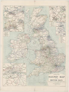
| Title: | Philips' railway map of the British Isles with large scale inset maps of the principal industrial centres. |
| Imprint: | [London, 1916] |
| Pagination: | 1 map ; 955 x 755 mm. |
| Shelfmark: | Map.l.9.50 |
| Notes: | Scale 1:1,140,480;Scale varies 1:1,235,520 Insets: London District; Edinburgh & Glasgow District; Lancashire & Yorkshire Manufacturing Districts; Newcastle & Middlesbrough Districts [and] The Midlands Manufacturing Districts [at varying scales] |
| Zoom Into Map: | Click on the map to view in greater detail. |