Map images
Search:
Maps home
>
Bathymetrical Survey of Fresh-Water Lochs, 1897-1909
Bathymetrical Survey of the Fresh-Water Lochs of Scotland, 1897-1909
Map details:
Field
Content
Map details:
Field
Content
Name:
Murray, Sir John (1841-1914)
Pullar, Laurence
Title:
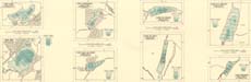
Loch Crunachan; Loch Caol na Doire; Loch na Cuaich; Loch an Duin; Loch Alvie; Loch Insh; Loch an t-Seilich; Loch Bhradain (Vol. 5, Plates 56, 57 & 59)
Imprint:
[London] : Royal Geographical Society, surveyed 1902-1904, published 1908.
Pagination:
8 maps on 1 sheet : col. ; 24.8 x 67.5 cm.
Shelfmark:
Map.B.1.c
Notes:
From:
Bathymetrical Survey of the Fresh-Water Lochs of Scotland
; constructed under the direction of Sir John Murray And Laurence Pullar during the years 1897 to 1909
Further information from the UK Lakes Portal:
Loch Alvie
Loch Insh
Loch Crunachdan
Loch Caoldair
Loch Cuaich
Zoom into Map:
Click on the map to
view in greater detail
.
View text pages:
Loch Crunachan
Loch Caol na Doire
Loch na Cuaich
Loch an Duin
Loch Alvie
Loch Insh
Loch an t-Seilich
Loch Bhradain