Blaeu Atlas Maior, 1662-5 - Further information
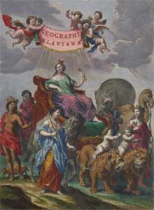
The Blaeu Atlas Maior or Cosmographia Blaviana is one of the largest and most splendid of the multi-volume Dutch world atlases. Published in 1662-5, its 594 maps and 3,368 pages of texts collectively presented the state of geographic knowledge of the world in the mid 17th century. Volume VI of the work was devoted to maps of Scotland and Ireland, bringing forward the original mapping of Scotland from the work of Timothy Pont, first published in Blaeu’s Atlas novus of 1654, into their final published form. The Atlas Maior was the most expensive book that could be acquired in the mid-17th century - a lavish and splendid item for display by its powerful and wealthy customers. This edition with Latin text in eleven volumes (Koeman 2:602; van der Krogt, 2005) was mostly printed in 1662; the title page on the first volume dates from a 1665 reprint. The Blaeu Atlas Maior was subsequently published with French, Dutch, German, and Spanish texts.
We are very grateful to David Rumsey for supporting the scanning and wider dissemination of this atlas.
View the Blaeu Atlas Maior
Background
The Blaeu Atlas Maior brought to fruition the largest map publishing project the world had seen, and it reflected a number of important background factors: the emergence of the atlas idea and its growing popularity in Europe; the influences of Abraham Ortelius and Gerard Mercator; new geographic discoveries and a growing public interest in publications which reflected the wider world; the rise of the Low Countries and Amsterdam as centres of printing and map production; and the intense competition between Janssonius and Blaeu in their rival grand atlas projects.
Abraham Ortelius (1527-1598) is credited with publishing one of the world’s first atlases, Theatrum Orbis Terrarum in 1570, bringing together a set of maps to a regular specification in a single volume. It was a great commercial success, with many later editions and reduced versions in smaller formats, also encouraging similar work by Ortelius’ friend, Gerard Mercator (1512-1594). Mercator’s world atlas Atlas sive cosmographiae meditationes de fabrica mundi et fabrica figura / Atlas, or Cosmographical Meditations on the Creation of the World and the Form of Creation was published in 1595 to wide acclaim, with maps and texts of the world carefully synthesized from disparate sources, forming part of a broader cosmographical treatise.
- View maps of Scotland in the atlases of Ortelius (1573) and Mercator (1595).
The purchase of Mercator’s copper plates in the early 17th century allowed Jodocus Hondius (1563-1612) and his heirs to publish steadily expanding atlases, combining Mercator’s respected maps with their own new ones. Timothy Pont (ca. 1565-1614), Scotland’s first topographer and map-maker, had a map of the Lothians engraved by Hondius around 1610, in his initial efforts to get his maps of Scotland put into print. This map of the Lothians was eventually published in 1630, although it would be Hondius’ rival, the firm of Blaeu, who in the end published the main bulk of Pont’s work in Volume V of the Atlas novus, often called the Blaeu Atlas of Scotland (1654).
From the early 17th century, Amsterdam emerged as the main centre for map production in the world, a role that had been briefly enjoyed by Antwerp until its decline in the 1580s. This was the Golden Age of the Dutch Republic, when it enjoyed a major economic, cultural and artistic boom. Helped by the growth of its overseas empire, with expanding trading networks and continued technological innovation, Dutch economic, political, and intellectual life flourished. The Dutch educational system, with its strong humanist roots, came to be highly regarded throughout Europe; their curricula too had a strong emphasis on mathematics and geometry, and in their practical application. Their high standards of literacy combined with a keen and growing interest in geographic discovery also encouraged an expanding market for travel narratives, maps, atlases and globes.
From the 1630s, the competition between the rival publishing houses of Hondius and Blaeu became ever more intense. Jodocus Hondius’ heirs, his son Henricus (1596/7-1651) and son-in-law Johannes Janssonius (1588-1664) exploited something of a monopoly position by bringing out ever-expanding folio atlases of the world, in different languages, and with a steady increase in the number of volumes. However, they were deeply shocked in 1630 to see Blaeu publishing his Atlantis appendix sive pars altera with 60 maps, most of which derived from purchasing a set of copper plates from Jodocus Hondius the Younger, who had died the previous year. Janssonius and Henricus Hondius responded immediately by publishing a ‘new’ atlas with maps copied from Blaeu, initiating a battle with each publisher trying to outdo their rival by bringing out ever-larger atlases. From the late 1630s, both published their own respective Atlas novus volumes, and over the next two decades, these publications expanded to become the Novus Atlas absolutissimus or Atlas Maior by the 1660s. Aesthetic considerations such as luxury bindings, fine engraving, attractive colouring and beautiful typography were emphasised, recognising the presentational value of the atlas as a status symbol for its purchasers. Currency of information and a consistent, even geographic coverage, were increasingly sacrificed in pursuit of publishing bulk - producing the largest and most magnificent world atlas.
Until the late 1650s, the Hondius-Janssonius atlases arguably had the competitive advantage over Blaeu. For example, in 1658, the Hondius-Janssonius Atlas novus had 450 maps, compared to Blaeu’s 403, and it provided a more balanced geographic coverage, although both covered the world in six volumes. Jansonnius went on to produce his Novus Atlas absolutissimus in ten or eleven volumes, usually containing 500-550 maps, in a work which was closer to Mercator’s ideal of a description of the whole universe as well as the world. However, it was not a very coherent work, with no special text written for it, and it lost momentum and support after Janssonius died in 1664. Blaeu meanwhile worked hard to expand his map coverage through a mixture of purchasing and copying other maps, so that his Atlas Maior volumes usually had around 600 maps, 200 more than his previous Atlas novus volumes. Although it failed to live up to its title as Geographia, quae est cosmographiae Blavianae pars prima / Geography, the First Part of Blaeu’s Cosmography - and the planned second and third parts with their maps of the seas and the universe were never published - in its size, execution, consistency, and appreciation - it was justly described as “the greatest and finest atlas ever published" (Verwey, 1952).
- Read a Biography of Joan Blaeu, (c. 1599-1673) from the Blaeu Atlas of Scotland (1654) website.
Principal Sources
world - view zoomable image
In common with other map publishers of the 17th century, Blaeu used a wide variety of source material for the Atlas Maior; most of it was quite dated and had been previously published. In a small minority of cases, he was able to source new material from a recent survey, such as the maps of Schleswig-Holstein by Johannes Meyer, but this was a rarity. Far more often, Blaeu relied on much earlier surveys (for example, the maps of Scotland based on Timothy Pont’s surveys over fifty years earlier) or copied the best available printed maps from other publishers, again often decades after their original publication. These copies were often changed to match Blaeu's style, aesthetics and ornamentation: the Blaeu maps of England and Wales deriving from John Speed, for example, or his maps of Italy deriving from Giovanni Magini, look distinctively different from their originals, even if their source topographic content is largely the same. Often Blaeu was able to re-use plates from his other atlas projects to provide bulk, and he also acquired copper plates where possible, such as those from Caspar Danckwerth's Newe Landesbeschriebung der zweij Herzogthümer Schleswig und Holstein (1652). As a final fallback, the plates of the great masters such as Ortelius and Mercator could also be used.
This brief summary of the sources for each volume is primarily taken from the more detailed listing by Koeman (1970), Chapter 5.
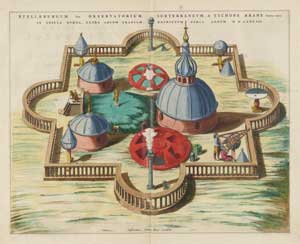
Volume 1 - Northern Europe, Norway, Denmark and Schleswig. Whilst some this material had been published previously in the 1630s, a number of fresh new maps were engraved especially for the Atlas Maior , including maps of the Arctic, and maps of Schleswig-Holstein by Johannes Meyer (1606-1674), recently engraved for Caspar Danckwerth’s Newe Landesbeschriebung der zweij Herzogthümer Schleswig und Holstein (1652). The 11 plates illustrating astronomical instruments and related architectural drawings and views from Tycho Brahe’s observatory on the the Island of Hven in the Baltic, were largely based on woodcut illustrations in Tycho Brahe's Astronimiae Instauratiae Mechanicae (1598). Willem Blaeu had spent several months in Brahe’s observatory in 1596, taking celestial observations and constructing celestial globes, and these plates were not published elsewhere.
Volume 2 - Sweden, Russia, Poland, Eastern Europe and Greece. Several of the maps of Sweden derive from Andreas Bureus, head of the Swedish Land Survey, which was founded in 1628, and the maps date from a decade around this time. The map of Russia by Hessel Gerritz was originally drawn in 1613, and the town plan of Moscow and the Kremlin / Kremlenagrad may also derive from Gerritz. However, some of the other detailed maps of Russia were more recent: for example, Rvssiæ, vulgo Moscovia, Pars Australis and Rvssiæ, Vulgo Moscovia dictæ, Pars Occidentalis are by Isaac Massa, published in 1662 (albeit based on an earlier itinerary). Seven of the ten maps of Poland were first issued in 1662, although three of them pre-date 1638. Most of the maps of Eastern Europe and Greece date from before 1640, although some are copies of maps by Johann Lauremberg, issued in 1650.
Volume 3 - Germany. The 97 maps of German provinces have a complex provenance, dating over the previous 50 years. 42 of the 97 were fresh compilations for the Atlas Maior, several of these from Danckwerth’s Newe Landesbeschriebung der zweij Herzogthumer Schleswig und Holstein (1652), as well as maps of Silesia by Johann Schultz of Sprottau, dating from around 1650.
Volume 4 - The Netherlands. As Blaeu’s home country, it seems surprising how dated many of these maps were, many having been published in earlier atlases of the 1630s. The volume opens with Willem Blaeu’s map of the XVII Provinces originally issued in 1608. It includes plates acquired from Hondius in the 1620s and plates deriving from Sanderus’ Flandria Illustrata of 1641. It also includes six maps of the polders of northern Holland acquired from the stock of Claes Jansz Visscher.
Volume 5 - England. The provenance of this volume is much simpler, deriving from various editions of John Speed’s Theatre of the Empire of Great Britain originally published in 1611. The texts derive largely from William Camden’s Britannia. Blaeu originally published this as Volume IV of the Atlas novus in 1645, and they were re-issued without alteration in 1662.
Volume 6 - Scotland and Ireland. This volume, containing 49 maps of Scotland and 6 of Ireland, along with 170 pages of descriptive text, was originally published as Volume V of Blaeu’s Atlas novus in 1654. The maps are largely the work of Timothy Pont (ca. 1583-1614), with additions by Robert Gordon of Straloch and his son James Gordon of Rothiemay (ca. 1636-1652). Our Blaeu Atlas of Scotland (1654) website includes a complete facsimile of the maps and texts, and a translation of the volume texts into English, along with detailed accompanying essays, with gazetteers of the placenames and personal names in the texts. The following essays also contain detailed information on the provenance of the Blaeu maps in the Atlas Novus and Atlas Maior, as well as the history behind their publication from Pont’s death until 1654:
- A Vision of Scotland: Joan Blaeu and the Atlas novus
- The history behind the publication of the Blaeu Atlas of Scotland, 1654
Although there were minor corrections to the text (particularly from Sir John Scot of Scotstarvit) and the text was reset for the Atlas Maior edition of 1662, the only changes to map plates were the addition of compass bearings and ships on 28 map plates where they were originally lacking. (Compare, for example, the map of Lewis and Harris from 1654 with the map of Lewis and Harris from 1662, the latter with compass roses, loxodromes orcompass bearings and ships).
Volume 7 - France and Switzerland. Most of these maps were issued in previous editions of Blaeu’s atlases from the 1630s onwards, and derive variously from Maurice Bouguereau’s Le Théatre Francoys (1594-), Jean le Clerc’s Le Théatre géographique du Royaume de France (1619-), as well as from other maps by Hondius and Janssonius. There are a small number of newer maps of France, some of which derived from the Geographer to the King of France, Pierre Du Val. The six maps of Switzerland in the atlas had been in print for several decades: four of them were copied from Mercator’s 1585 Galliae Tabulae geographicae.
Volume 8 - Italy. This volume resembles very closely the third volume of Blaeu’s Atlas Novus published in 1640. The maps and texts were derived from the Italian astronomer and geographer, Giovanni Magini from his Italia of 1620. The Atlas Maior has only a few additional maps.
view zoomable image
Volume 9 - Spain and Africa. Most of the maps of Spain and Portugal had been published by Blaeu in earlier editions of his atlases in the 1630s. The volume was expanded for the Atlas Maior by the addition of several striking plates of the Escorial royal palace. There were also some new maps added of Portugal by the Joao Baptista Lavanha, dating from original maps of ca. 1615. The map of the Azores was originally drafted by Luis Teixeira, and used by Abraham Ortelius in 1584.
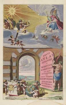
Volume 10 - Asia. Joan Blaeu had close connections with the Dutch East India Company (V.O.C.), acting as their official cartographer, but he was not permitted to publish maps based on their files. Instead, Blaeu published 17 detailed maps and 171 pages of text of China based on the work of the Italian Jesuit Missionary, Martino Martini (1614–1661). This appeared within the volumes as the Novus Atlas Sinensis.
Volume 11 - America. The 29 maps of the Americas are largely reprints from earlier maps published in the Blaeu atlases of the 1620s and 1630s. Five maps of Brazil derive from a volume by Caspar Barlaeus Rerum per Octennium in Brasilia et Alibi Nuper Gestarum sub Praefectura Comitis Joannis Mauritii... which Blaeu published in 1647.
Geographic arrangement
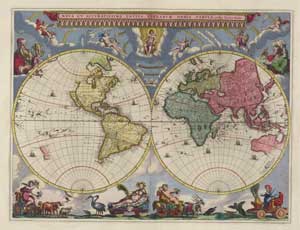
The Blaeu Atlas Maior was published in 11 volumes, with its geographical contents arranged into five (uneven) parts of the world; the titles of these five parts appear within the volumes.
View the Table of the World, and the volumes in which they appear.
- Part I covered the North Pole Region, the initial section of Volume 1
- Part II covered Europe, including the rest of Volume 1, and Volumes 2-9
- Part III covered Africa, the latter part of Volume 9
- Part IV covered Asia and China in Volume 10
- Part V covered America, in Volume 11
Printing
The Blaeu printing presses were the largest in the world at the time; impressive industrial-scale operations, described in glowing terms by visitors from afar. The main older press was located on Bloemgracht with 9 presses for books and 6 presses for maps, employing perhaps over 80 men working full-time. In 1667 a second press was acquired at Gravenstraat, where most of the map plates were probably printed. The disastrous fire of 1672 in Gravenstraat, which seriously damaged Blaeu as a publisher, resulted in major losses of map plates.
Given their size, the labour which went into every Atlas Maior volume was enormous. Even if we exclude the significant work involved in compiling, drawing and engraving all the maps (which was done elsewhere), a single volume of the Blaeu Atlas Maior took over 7 man-years just to set the type. These figures below, based on good estimates by van der Krogt (2005), take the Latin 1662 volume with its 594 maps and 3,368 pages of texts, and assume a typical 10 hour working day.
Approximate time taken to compose and print a typical Blaeu Atlas Maior volume:
| Typesetting | 440 mins per page | 2,400 days or 7 years |
| Printing texts | 50 sheet per hour | 33 days |
| Printing maps | 10 maps per hour | 6 days |
| Binding | 100 sheets per hour | 8 days |
Note: The typesetting work would only be done once for then printing multiple volumes thereafter.
The Blaeu Atlas Maior was produced to order for particular customers, and so there was not a standard ‘print run’. However, based on the surviving Blaeu Atlas Maior volumes today, van der Krogt (2005) reckons there were around 650 copies printed of the Latin edition (1662-5), 400 of the French edition (1664), 300 of the Dutch edition (1664-65), and 200 of the Spanish edition (1659-72). This translates into printing some 950,000 map pages, and 5,440,000 text pages - a staggering achievement, even when spread over several years. Based on Blaeu’s catalogues of 1670, the Blaeu Atlas Maior sold for between 350 guilders (uncoloured) to 450 guilders (coloured). This was a similar sum of money at the time to renting a shop or a farm in the Netherlands for a year, or a decent annual salary for a 17th century craftsman. It was the most expensive book that could be bought in the 17th century (van der Krogt, 2005).
References
Brotton, J. (2012). A history of the World in Twelve Maps. London: Penguin.
Keuning, J. & rev. and ed. by Marijke Donkersloot-de Vrij (1973). Willem Jansz. Blaeu : a Biography and History of His Work as a Cartographer and Publisher. Amsterdam : Theatrum Orbis Terrarum.
Koeman, C. (1970). Joan Blaeu and His Grand Atlas. Amsterdam: Theatrum Orbis Terrarum.
Koeman, C., Günter Schilder, Peter van der Krogt & Marco van Egmond (2007). ‘Commercial Cartography and Map Production in the Low Countries, 1500-ca. 1672’, In: David Woodward (ed.), The History of Cartography, Volume Three : Cartography in the European Renaissance, 1323-1330. Chicago: University of Chicago Press.
Krogt, P.C.J. van der (2000). Koeman’s Atlantes Neerlandici New Edition: Volume II: : the Folio Atlases Published by Willem Jansz. Blaeu and Joan Blaeu, 316-7 and 383-406. ’t Goy-Houten, HES.
Krogt, P.C.J. van der (2005). 'The Atlas Maior of Joan Blaeu', In: Joan Blaeu Atlas Maior of 1665 : "the greatest and finest atlas ever published". Köln : Taschen, 2005.
Verwey, H. de la Fontaine (1952). 'Het werk van de Blaeus', Maandblad Amstelodamum 39, 97-104.
View the Blaeu Atlas Maior