Pont maps | Pont texts | biographies | history | subjects | further reading
Scottish woodlands

Pont's manuscript maps, combined with his textual descriptions of the country, tell us a great deal about Scottish woodland in the late 16th century.
As the earliest surviving detailed maps of Scotland, the Pont manuscript maps provide the first graphic depiction of the size, shape and even density of woodland for many areas of Scotland. Related to this, his maps often show whether woods were open or enclosed, and, in the case of the latter, possibly even the means of enclosure (e.g. fence, wall, or ditch). In a few areas, the types of tree in a wood, and the function of the woodland (e.g. deer park, orchard, or a source of timber, or firewood) are also mentioned.

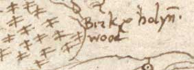
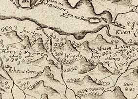
Pont's maps confirm that the 'great Caledonian forest' which was once supposed to have survived across large tracts of Scotland until the 17th century, had largely disappeared well before the 16th century. The woodland shown by Pont is already confined to planted enclosures around the larger houses and abbeys in the Lowlands, or clustered in valleys and the occasional tract of deer forest further north in the Highlands. His remarks wood & very pleasant orch[ard] and gardens about the cast[le] of Innermarke (Invermark in Angus) on Pont 30, and his veill beutified vith gardens, orchards and partiers (parterres) about Blair Castle in Cunningham (Fullarton, 1858, p.12) are typical, and could have also been made of many other formal gardens at this time (Dingwall, 1999). Further north, his record of tree species fits with what we would expect, with pine and birch predominating. For example, in Strathnavar in Sutherland he records birk & holyn wood (Pont 2); south of Loch Leven in Argyll he records many fyrre woods heir alongs (Pont 13); and in Glen Tulchan, Strathspey, he records al this glen birk wood (Pont 6), one of many references to trees on this map.

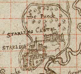
Most of Pont's woodland, such as the okewood near Thornhill in Dumfries-shire, is not delimited, but around some larger buildings and castles Pont clearly shows boundary lines. For example, by Darnaway Castle in Moray, with its royal forests used for many medieval building schemes, it is possible to see an enclosed marked park area, managed park to the north, and wood pasture to the south (Smout, 2001). The use of a double line to indicate a walled boundary can be seen on many of Pont's maps. A double line encloses the hunting park north of Stirling Castle, as well as woods beside Cumbernauld and Callendar Castles (Pont 32). And is Pont possibly showing paling fences bounding woodland by Inverarity (Pont 26) or in front of Castle Menzies (Pont 23)?
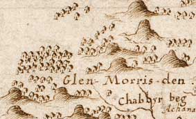
Despite these evident strengths, there are several difficulties in interpreting Pont's depiction of woodland. Pont's manuscripts only survive for parts of Scotland, and the various Gordon and Blaeu maps based on Pont's work for other areas tend to distort and considerably expand woodland, arguably for aesthetic reasons. On Pont's manuscripts, woodland tends to be a residual feature, to be omitted in more densely inhabited country in favour of buildings, settlements, and their names. A further source of confusion is the apparently inconsistent use of symbols for trees, with both stick-like, and rounded forms of tree-symbols being used (and with perhaps two forms of the latter occurring). Attempts to explain these as indicating different tree types (e.g. conifer/broadleaf), or the economic viability of a wood, or a change in style through time all fall down against evidence in the field (Smout, 2001), and the most plausible explanation is that not all the symbols were drawn by Pont himself. It is certainly true that Robert Gordon's tree in darker ink can be seen extensively on Pont's maps, and we have to look beneath his symbols to glean what might have been Pont's original record.

Despite these problems, Pont's maps are an essential source for anyone interested in Scottish woodland history, and when integrated with later maps by Roy and the Ordnance Survey, a sequence of woods through time can be constructed leading up to the present day. This has great value in determining 'ancient woodland' - the most ecologically diverse woods that have survived for centuries - as well as the changing pattern of tree cover through time (Smout, 2001).
The fullest discussion of Pont's importance in the study of Scottish woodlands is to be found in Professor Christopher Smout's chapter, 'Woodland in the Maps of Pont', in The Nation Survey'd, edited by Ian C. Cunningham.
